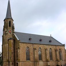
St. Marien
770 m
Hootzemonn-Weg
1.3 km
Hilgenbacher Höhe
1.6 km
Bilsen-Berg
1 km
Wengenwald mit Schaeferbachtal und Hirteler Tal
1.8 km
Kallenborn
1.6 km
Landschaftsschutzgebiet im Landkreis Saarlouis - im Bereich der Gemeinden Saarwellingen und Lebach
572 m
Wayside cross
934 m
1887-1997
1.4 km
Kup
1.6 km
Wayside cross
1.4 km
Christianity, wayside cross
1.2 km
Kreuz Hilgenbacher Höhe
1.7 km
Heinrich
910 m
Geografischer Mittelpunkt des Saarlandes
1.8 km
Marienkreuz
1.2 km
Bittkreuz
869 m
Wayside cross
1.3 km
Naturpark Kallenborn
1.5 km
Wayside cross
1.1 km
Wayside cross
1.1 km
Ziegler/Lesch
1.5 km
Brück / Buhl
1 km
Wayside cross
1.6 km
Mariengrotte
1.1 km
Wayside cross
707 m
Wayside shrine
1.7 km
Brack
1.7 kmReviews
Visited this place? Tap the stars to rate it and share your experience / photos with the community! Try now! You can cancel it anytime.
Discover hidden gems everywhere you go!
From secret cafés to breathtaking viewpoints, skip the crowded tourist spots and find places that match your style. Our app makes it easy with voice search, smart filtering, route optimization, and insider tips from travelers worldwide. Download now for the complete mobile experience.

A unique approach to discovering new places❞
— Le Figaro
All the places worth exploring❞
— France Info
A tailor-made excursion in just a few clicks❞
— 20 Minutes