Wayside shrine
Location: Spiegelau
Inscription: MARYAM
GPS coordinates: 48.91142,13.36576
Latest update: November 13, 2025 09:48
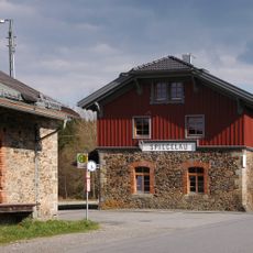
Station building at Spiegelau station
845 m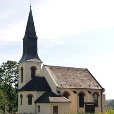
Martin Luther Church
449 m
Katholische Pfarrkirche St. Johannes der Täufer
545 m
Kapelle
172 m
Schutz von Landschaftsteilen in den Gemeinden Oberkreuzberg, St. Oswald, Großarmschlag, Hartmannsreit und Schlag des Landkreises Grafenau (LSG Große Ohe von der Steinklamm bis zu Stadlmühle)
963 m
Cultural heritage D-2-7046-0004 in Sankt Oswald-Riedlhütte
1.4 km
Ehemaliges Forstamtsgebäude
383 m
Bayerwald observatory
1.8 km
Bahnhof Nähe Bahnhofstraße in Spiegelau
872 m
Cultural heritage D-2-7046-0023 in Spiegelau
1.9 km
Nebengebäude Bahnhofstraße 10 in Spiegelau
824 m
Kapelle
1.5 km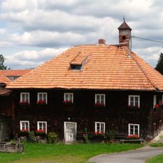
Hakenhof
141 m
Barfußpfad mit sehenden Füßen und Händen
1.1 km
Wayside cross
1.8 km
Wald-Glas-Garten
994 m
Marien-Höhe
780 m
Scenic viewpoint
1.7 km
Scenic viewpoint
685 m
Erinnerung a.d. Erschließung d. Grenzwälder i. Bayer. Wald
1.1 km
Bayerwald observatory
1.8 km
Wetterpilz
1.7 km
Holzkreuz
1.7 km
Geburtshaus v.Paul Friedl (Baumsteftenlenz)
139 m
Spiegelauer Waldbahn
826 m
Memorial cross, memorial
1 km
Ruins
932 m
Wayside cross
806 mReviews
Visited this place? Tap the stars to rate it and share your experience / photos with the community! Try now! You can cancel it anytime.
Discover hidden gems everywhere you go!
From secret cafés to breathtaking viewpoints, skip the crowded tourist spots and find places that match your style. Our app makes it easy with voice search, smart filtering, route optimization, and insider tips from travelers worldwide. Download now for the complete mobile experience.

A unique approach to discovering new places❞
— Le Figaro
All the places worth exploring❞
— France Info
A tailor-made excursion in just a few clicks❞
— 20 Minutes