Hochwassermarke
Location: Wesseling-Mitte
Location: Wesseling
Reference: 109
Fee: No
Inscription: Hochwasser Neujahr 1925-26 - Stand am 1.Jan.26
GPS coordinates: 50.82670,6.98372
Latest update: November 26, 2025 02:29
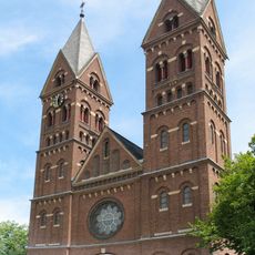
St. Germanus (Wesseling)
119 m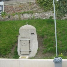
Einmannbunker Wesseling
39 m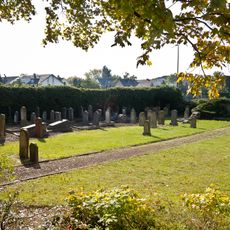
Jewish Cemetery in Wesseling
328 m
Fränkische Plattengräber
289 m
Nanny Wolff
151 m
Heiliger Georg
187 m
Penelope
223 m
Rathaus Uhr
259 m
Wessel de Ling
281 m
Jakobsmuschel-Stele
188 m
Work of art, statue
180 m
Statue, Work of art
89 m
Mural, Work of art
293 m
Scenic viewpoint
222 m
Phönix Theater
189 m
Archaeological site
79 m
Windrad
274 m
Jakob Wolff
151 m
Johanna Mayer
152 m
Julie Mayer
152 m
Karl Koppel
341 m
Johanna Koppel
341 m
Lina Koppel
341 m
Archaeological site
278 m
Höhenmarke
115 m
Grabdenkmal Wedler
332 m
Grabdenkmal Heister
333 m
Grabdenkmal Pilgram
339 mReviews
Visited this place? Tap the stars to rate it and share your experience / photos with the community! Try now! You can cancel it anytime.
Discover hidden gems everywhere you go!
From secret cafés to breathtaking viewpoints, skip the crowded tourist spots and find places that match your style. Our app makes it easy with voice search, smart filtering, route optimization, and insider tips from travelers worldwide. Download now for the complete mobile experience.

A unique approach to discovering new places❞
— Le Figaro
All the places worth exploring❞
— France Info
A tailor-made excursion in just a few clicks❞
— 20 Minutes