Vehicle, minecart
Location: Urexweiler
Location: Marpingen
GPS coordinates: 49.43010,7.07477
Latest update: November 20, 2025 03:07
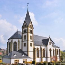
Mariä Himmelfahrt
3 km
St. Franziskus (Urexweiler)
63 m
Faulen-Berg
2.6 km
Weinhausköpfchen
3 km
Bastberg
2.9 km
Naturschutzgroßvorhaben Ill
875 m
Hammers-Berg
1.4 km
Frankenbach - Kaselswald
3 km
Heimatmuseum Urexweiler
148 m
Steinbrüche Hirst und Gassenheck
2.6 km
Frankenbacher Hof (Naturwaldzelle)
2.3 km
Landschaftsschutzgebiet im Landkreis St. Wendel - in der Gemeinde Marpingen
1.5 km
Frankenbacher Hof
2.9 km
Landschaftsschutzgebiet im Landkreis St. Wendel - in der Gemeinde Marpingen
2.6 km
Streichelzoo
2.8 km
Friedenskreuz
2.9 km
Segelflugplatz Wustweiler
2.6 km
Scenic viewpoint
2.1 km
Scenic viewpoint
2.8 km
Scenic viewpoint
1.5 km
Scenic viewpoint
2.9 km
Bergmannskreuz
1.9 km
Marpinger Grubenstollen
1.9 km
Keltischer Grabhügel
1.2 km
Wayside cross
423 m
Wayside cross
2.7 km
Wayside shrine, Christianity
2.3 km
Wayside shrine, Christianity
2.8 kmReviews
Visited this place? Tap the stars to rate it and share your experience / photos with the community! Try now! You can cancel it anytime.
Discover hidden gems everywhere you go!
From secret cafés to breathtaking viewpoints, skip the crowded tourist spots and find places that match your style. Our app makes it easy with voice search, smart filtering, route optimization, and insider tips from travelers worldwide. Download now for the complete mobile experience.

A unique approach to discovering new places❞
— Le Figaro
All the places worth exploring❞
— France Info
A tailor-made excursion in just a few clicks❞
— 20 Minutes