Malay Peninsula, Peninsula in Southeast Asia
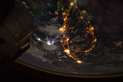
The Malay Peninsula extends over 1,100 kilometers from the Isthmus of Kra in the north to Cape Piai in the south, forming the southernmost tip of the Asian mainland. A central mountain range divides the peninsula into western and eastern sides with different landscapes and coastal zones.
Ancient Greek traders called the region Chersonesus Aurea and recognized its position on important sea routes between East and West. The peninsula served for centuries as a trade bridge for spices, silk, and other goods between Asia and the rest of the world.
The peninsula links several nations and forms a passage between mainland Asia and the southern island groups. Local communities live along the coasts and have relied on the sea for fishing and trade for centuries.
The western coast receives rain from the southwest monsoon between May and September, while the eastern coast gets wet between November and February. Travelers should plan their route according to the monsoon patterns to take advantage of the drier months on both coasts.
Rivers on the western side are short and carry heavy sediment near the coast, while eastern rivers run longer and have gentle slopes in their upper sections. These different river systems shape land use and settlement patterns along both coasts in different ways.
The community of curious travelers
AroundUs brings together thousands of curated places, local tips, and hidden gems, enriched daily by 60,000 contributors worldwide.