Chest opened
+${chestReward.xp} XP
Explorer
NOUVEAU ×${chestReward.collectible.quantity}
tapez pour fermer

See the monuments around you in AR Open chests in the app

Around Us is built for your phone — point your camera at the streets and discover the monuments and places around you in augmented reality. Around Us is built for your phone — chests unlock when you walk, explore and capture nearby places.

•

Enable Location

We need your location to show you interesting places around you

Discover nearby places

Find interesting locations and hidden gems around you

Precise directions

Get accurate directions and distances to places

Your location is never shared with other users. It's only used when you tap the location button.

Mount Tandikat

Log in to your account

Start exploring — it's free

Trusted by 94,794 travelers worldwide

Continue with Google
Continue with Apple
or

We will send you a code to connect

By continuing, you accept our Terms and Conditions and our Privacy Policy

Check your inbox

We've sent a pincode in your inbox. Please enter the code below.

Mount Tandikat

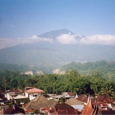
Mount Tandikat, Stratovolcano in West Sumatra, Indonesia

Mount Tandikat is a 2,438 m active stratovolcano in West Sumatra, 7.5 km from Padang Panjang. It is the twin of Mount Singgalang to its north-north-east, but only Tandikat has recorded historical eruptions. Its summit holds three craters, named A, B and K, and the mountain stretches north to south, with Lake Maninjau to the west.

Mount Tandikat is a Quaternary stratovolcano built largely from andesite lava flows, with early eruptions around 52,000 years ago producing hornblende-hypersthene pumiceous tuff. It has two magma chambers, a shallow one about 5 km deep and a deeper one of unknown depth. On 30 April 2009 a magnitude 7.6 earthquake triggered a large debris avalanche on its slopes, the most extensive of many landslides that day, killing hundreds of people.

The Minangkabau name Tandikek is paired with the title Puncak Tri Arga, "supporter of the Minang sky", shared with Singgalang and Marapi. Climbers on the Singgalang Ganting route often spend the night in the village of the mountain's kuncen, its traditional guardian, before setting out the next morning.

The usual route starts from Lembah Anai Resort, where a trail was opened in 1998 by a Mapala Unand team; it took them five days up and two down. Paths are faint or broken, leeches are common between 650 and 1,700 m, and a guide is needed to avoid getting lost. The Singgalang Ganting village route begins after a stay with the mountain's kuncen.

The 30 April 2009 earthquake, magnitude 7.6, triggered the largest of many landslides on Tandikat's slopes; loose pumice and 30–50 degree gradients let the flank flow downhill and hundreds of people died. The mountain's andesite lavas come from two magma chambers, a shallow one about 5 km down and a deeper one of unknown depth.

The community of curious travelers

AroundUs brings together thousands of curated places, local tips, and hidden gems, enriched daily by 94,794 contributors worldwide.

Start exploring
GPS coordinates
-0.43069,100.31787
Latest update
October 29, 2026 00:03
Reviews
Share your experience

No review yet

Discussions
Start a discussion...

No discussion yet

« Mount Tandikat - Stratovolcano in West Sumatra, Indonesia » is provided by Around Us (aroundus.com). Images and texts are derived from Wikimedia project under a Creative Commons license. You are allowed to copy, distribute, and modify copies of this page, under the conditions set by the license, as long as this note is clearly visible.

Discover hidden gems everywhere you go!

From secret cafés to breathtaking viewpoints, skip the crowded tourist spots and find places that match your style. Our app makes it easy with voice search, smart filtering, route optimization, and insider tips from travelers worldwide. Download now for the complete mobile experience.

Around Us App Screenshot
❝

A unique approach to discovering new places❞

— Le Figaro

❝

All the places worth exploring❞

— France Info

❝

A tailor-made excursion in just a few clicks❞

— 20 Minutes

Around Us
Travel Guide & Maps
Download

Send to your phone

QR Code
1

Open the camera app on your mobile.

2

Point at the QR code with your camera. A notification will appear.

3

Tap the notification to open the link.