Chest opened
+${chestReward.xp} XP
Explorer
NOUVEAU ×${chestReward.collectible.quantity}
tapez pour fermer
Chest locked

Open chests in the app

Around Us is built for your phone — chests unlock when you walk, explore and capture nearby places.

Enable Location

We need your location to show you interesting places around you

Discover nearby places

Find interesting locations and hidden gems around you

Precise directions

Get accurate directions and distances to places

Your location is never shared with other users. It's only used when you tap the location button.

East Timor–Indonesia border

Log in to your account

Start exploring — it's free

Trusted by 72,916 travelers worldwide

Continue with Google
Continue with Apple
or

We will send you a code to connect

By continuing, you accept our Terms and Conditions and our Privacy Policy

Check your inbox

We've sent a pincode in your inbox. Please enter the code below.

East Timor–Indonesia border
Discussion Reviews 2 Photos
27.4k Popularity

East Timor–Indonesia border, International and maritime boundary between Indonesia and East Timor, Southeast Asia.

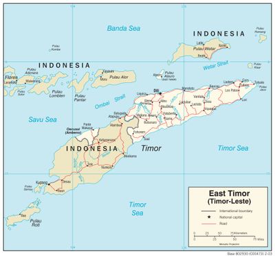
The border between Indonesia and East Timor is both a land boundary and a maritime boundary in Southeast Asia. The land border extends approximately 269 kilometers and separates Indonesia's East Nusa Tenggara province from East Timorese districts of Bobonaro, Cova Lima, and Oecusse.

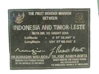
The border originated from colonial divisions between Portuguese and Dutch territories, formalized through the Treaty of Lisbon in 1859 and a Permanent Court ruling in 1914. After East Timor gained independence in 1999, the boundary took on its current international significance.

Communities on both sides maintain distinct traditions shaped by Portuguese colonial history on the East Timorese side and Dutch heritage in Indonesian territory. Despite the border, people share similar daily practices and local customs that extend across the political divide.

Border crossings require valid identification documents and passports for travel between the two countries. It is wise to check current entry regulations and any restrictions with authorities before attempting to cross.

The maritime boundary extends into the disputed Timor Sea, where questions about jurisdiction limits and resource rights remain ongoing negotiation topics. This uncertainty in maritime delimitation has long-term impacts on natural resource use in the region.

The community of curious travelers

AroundUs brings together thousands of curated places, local tips, and hidden gems, enriched daily by 60,000 contributors worldwide.

Start exploring
Part of
borders of Indonesia, meja Vzhodnega Timorja
GPS coordinates
-8.94910,124.94310
Latest update
December 20, 2025 13:48
Reviews
Share your experience

No review yet

Discussions
Start a discussion...

No discussion yet

« East Timor–Indonesia border - International and maritime boundary between Indonesia and East Timor, Southeast Asia » is provided by Around Us (aroundus.com). Images and texts are derived from Wikimedia project under a Creative Commons license. You are allowed to copy, distribute, and modify copies of this page, under the conditions set by the license, as long as this note is clearly visible.

Discover hidden gems everywhere you go!

From secret cafés to breathtaking viewpoints, skip the crowded tourist spots and find places that match your style. Our app makes it easy with voice search, smart filtering, route optimization, and insider tips from travelers worldwide. Download now for the complete mobile experience.

Around Us App Screenshot

A unique approach to discovering new places

Le Figaro

All the places worth exploring

France Info

A tailor-made excursion in just a few clicks

20 Minutes

Around Us
Travel Guide & Maps
Download

Send to your phone

QR Code
1

Open the camera app on your mobile.

2

Point at the QR code with your camera. A notification will appear.

3

Tap the notification to open the link.