Enable Location

We need your location to show you interesting places around you

Discover nearby places

Find interesting locations and hidden gems around you

Precise directions

Get accurate directions and distances to places

Your location is never shared with other users. It's only used when you tap the location button.

Log in to your account

Start exploring — it's free

Trusted by 63,536 travelers worldwide

Continue with Google
Continue with Apple
or

We will send you a code to connect

By continuing, you accept our Terms and Conditions and our Privacy Policy

Check your inbox

We've sent a pincode in your inbox. Please enter the code below.

Discussion Reviews Photo
25k Popularity

East Kotawaringin, Administrative region in Central Kalimantan, Indonesia

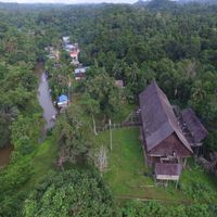
East Kotawaringin is an administrative region in Central Kalimantan with flat areas, gentle hills, and river landscapes spread across ten districts. It connects rural settlements with smaller town centers through a network of roads and waterways.

This regency was formed in 1959 when Kotawaringin Regency was divided, creating a separate administration that developed over decades. Later administrative changes in the early 2000s shaped the neighboring areas but left the core territory intact.

The regency is home to Dayak and Malay communities whose traditions show in local celebrations, crafts, and shared rituals that shape daily village life. These customs remain woven into how people mark seasons and gather together.

The region is best explored during the dry season, as flooding is common in the rainy season and can affect access to certain areas. The main road connecting the districts provides the best orientation for travelers moving between settlements.

The region holds significant coal deposits that have shaped its economy and development for decades, making mining a dominant activity across the landscape. This reliance on a single resource has influenced how the region grew and adapted over time.

The community of curious travelers

AroundUs brings together thousands of curated places, local tips, and hidden gems, enriched daily by 60,000 contributors worldwide.

Start exploring
Capital city
Sampit
Elevation above the sea
92 m
Shares border with
Katingan, Seruyan
GPS coordinates
-2.08333,112.75000
Latest update
December 20, 2025 11:52
Reviews
Share your experience

No review yet

Discussions
Start a discussion...

No discussion yet

« East Kotawaringin - Administrative region in Central Kalimantan, Indonesia » is provided by Around Us (aroundus.com). Images and texts are derived from Wikimedia project under a Creative Commons license. You are allowed to copy, distribute, and modify copies of this page, under the conditions set by the license, as long as this note is clearly visible.

Discover hidden gems everywhere you go!

From secret cafés to breathtaking viewpoints, skip the crowded tourist spots and find places that match your style. Our app makes it easy with voice search, smart filtering, route optimization, and insider tips from travelers worldwide. Download now for the complete mobile experience.

Around Us App Screenshot

A unique approach to discovering new places

Le Figaro

All the places worth exploring

France Info

A tailor-made excursion in just a few clicks

20 Minutes

Around Us
Travel Guide & Maps
Download

Send to your phone

QR Code
1

Open the camera app on your mobile.

2

Point at the QR code with your camera. A notification will appear.

3

Tap the notification to open the link.