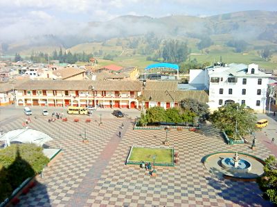
Chocontá, Mountain municipality in Almeidas Province, Colombia.
Chocontá is a mountain municipality in Cundinamarca department, positioned at approximately 2,700 meters (8,860 feet) elevation along the Pan-American Highway corridor. The settlement combines urban neighborhoods with surrounding rural farmland that defines the local landscape.
Spanish conquistadors led by Gonzalo Jiménez de Quesada arrived in the region around 1537, with the formal establishment of Chocontá as a settlement occurring in 1563. Colonial administration shaped the municipality's early organization and infrastructure.
The name Chocontá comes from the Chibcha language spoken by the Muisca people and means "farmlands of the good ally." This heritage remains visible in how locals relate to the surrounding land.
The municipality is most easily reached via the Pan-American Highway, which passes through the area as the main transportation route. Visitors should prepare for high elevation conditions and bring appropriate clothing for mountain weather.
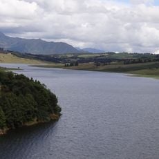
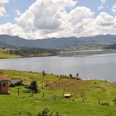
The area is known for strawberry cultivation and contains the Sisga Reservoir, an important water infrastructure project. This combination of agricultural production and engineering sets it apart within the region.
Location: Almeidas Province
Inception: 1563
Elevation above the sea: 2,689 m
Website: http://choconta-cundinamarca.gov.co
GPS coordinates: 5.14667,-73.68250
Latest update: December 7, 2025 09:28
Salt Cathedral of Zipaquirá
38.9 km
Jaime Duque
38.2 km
Puente de Boyacá
43.9 km
Embalse del Neusa
33.4 km
Castillo Marroquín
49.5 km
Represa del Sisga
8.9 km
Candelaria Desert
48.8 km
Hunzahúa Well
55.5 km
El Abra
33.1 km
Guavio Reservoir
53.9 km
Embalse de Chivor
45.1 km
Autódromo de Tocancipá
35.9 km
Puente del Común
50.7 km
Basílica del Santo Cristo de Ubaté
23.1 km
La pila del mono
55.5 km
Paja Formation
44.2 km
Museo Aeroespacial Fuerza Aeroespacial Colombiana
38 km
Páramo de Guacheneque
22.6 km
Cathedral of the Most Holy Trinity, Zipaquirá
38.1 km
Moon Temple
54.4 km
Paredón de los Mártires
55.2 km
Centro Chía
50.2 km
Yacimiento rupestre de Sáchica
52.7 km
La Esmeralda Dam
50.8 km
Alto de San Lázaro
54.9 km
Colombian Aerospace Museum
37.9 km
Lac del Neusa
30.8 km
Lac del Guavio
51.8 kmVisited this place? Tap the stars to rate it and share your experience / photos with the community! Try now! You can cancel it anytime.
Discover hidden gems everywhere you go!
From secret cafés to breathtaking viewpoints, skip the crowded tourist spots and find places that match your style. Our app makes it easy with voice search, smart filtering, route optimization, and insider tips from travelers worldwide. Download now for the complete mobile experience.
A unique approach to discovering new places❞
— Le Figaro
All the places worth exploring❞
— France Info
A tailor-made excursion in just a few clicks❞
— 20 Minutes