Réserve naturelle de la Rivière-du-Diable, natural reserve of Quebec
Location: Mont-Tremblant
Inception: March 12, 2014
GPS coordinates: 46.19270,-74.59490
Latest update: November 9, 2025 18:04
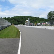
Circuit Mont-Tremblant
1.3 km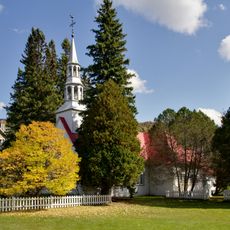
Chapelle Saint-Bernard
2.1 km
Pont du Village
2 km
Pont Beauvallon
170 m
Pont de la Cachée
1.2 km
Pont des Chutes
1.9 km
Pont du Marécage
1.9 km
Pont Jackrabbit
190 m
Vieux pont de Fer
2.4 km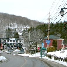
Le Village
2.3 km
Mission Laser
2.3 km
Plage du Pinoteau
1.7 km
Cabriolet Mont-Tremblant
2 km
Vélo Mont-Tremblant
2 km
Golf Le Diable
1.5 km
Ziptrek Écotours
2.4 km
Brind'O Aquaclub
2.3 km
Parc Plage
2.1 km
B&T - Beach & Tennis Club
1.8 km
Golf Le Diable
1.1 km
Belvédère des Chutes
2 km
Scenic viewpoint
1.8 km
Scenic viewpoint
1.8 km
Scenic viewpoint
2.1 km
Vue
745 m
Scenic viewpoint
800 m
Scenic viewpoint
2 km
Chutes
1.9 kmReviews
Visited this place? Tap the stars to rate it and share your experience / photos with the community! Try now! You can cancel it anytime.
Discover hidden gems everywhere you go!
From secret cafés to breathtaking viewpoints, skip the crowded tourist spots and find places that match your style. Our app makes it easy with voice search, smart filtering, route optimization, and insider tips from travelers worldwide. Download now for the complete mobile experience.

A unique approach to discovering new places❞
— Le Figaro
All the places worth exploring❞
— France Info
A tailor-made excursion in just a few clicks❞
— 20 Minutes