Réserve naturelle William-R.-J.-Oliver, natural reserve of Quebec
Location: Sainte-Agathe-des-Monts
Inception: June 21, 2006
GPS coordinates: 46.08333,-74.29833
Latest update: November 21, 2025 04:54

Pont de Préfontaine
5.4 km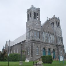
Église de Sainte-Agathe-des-Monts
4.3 km
Pont Beauchamp
6.6 km
Pont Degrosbois
5.6 km
Pont Parent
3.5 km
Ponceau St-Pierre
6.5 km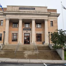
Ancien bureau de poste de Sainte-Agathe-des-Monts
3.9 km
Plage Sainte-Lucie
4.2 km
Pont du Village
3.2 km
Pont de la Gare
3 km
Pont Alouette
6.9 km
Pont de Château-Bleu
3.4 km
Plage Tessier
4.9 km
Pont Dupéré
5.7 km
Pont Therrien
6.5 km
Pont Châtillon
4.7 km
Réserve naturelle du Lac-Brûlé
3.5 km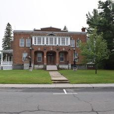
Presbytère de Sainte-Agathe-des-Monts
4.2 km
Golf Sainte-Agathe
3.4 km
Plage Ste-Lucie
4.2 km
Cap Beauséjour
3.6 km
Scenic viewpoint
3.2 km
Scenic viewpoint
4.3 km
Scenic viewpoint
4.2 km
Scenic viewpoint
5.4 km
Scenic viewpoint
6 km
Scenic viewpoint
5.9 km
Scenic viewpoint
2.4 kmReviews
Visited this place? Tap the stars to rate it and share your experience / photos with the community! Try now! You can cancel it anytime.
Discover hidden gems everywhere you go!
From secret cafés to breathtaking viewpoints, skip the crowded tourist spots and find places that match your style. Our app makes it easy with voice search, smart filtering, route optimization, and insider tips from travelers worldwide. Download now for the complete mobile experience.

A unique approach to discovering new places❞
— Le Figaro
All the places worth exploring❞
— France Info
A tailor-made excursion in just a few clicks❞
— 20 Minutes