Enable Location

We need your location to show you interesting places around you

Discover nearby places

Find interesting locations and hidden gems around you

Precise directions

Get accurate directions and distances to places

Your location is never shared with other users. It's only used when you tap the location button.

Federated States of Micronesia

Log in to your account

Start exploring — it's free

Trusted by 62,843 travelers worldwide

Continue with Google
Continue with Apple
or

We will send you a code to connect

By continuing, you accept our Terms and Conditions and our Privacy Policy

Check your inbox

We've sent a pincode in your inbox. Please enter the code below.

Federated States of Micronesia, Island country in western Pacific Ocean, Micronesia.

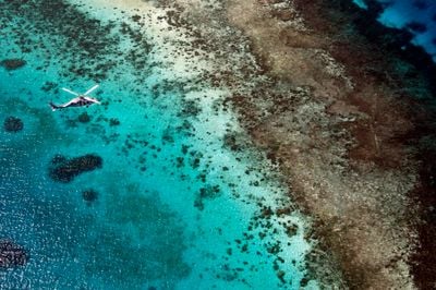
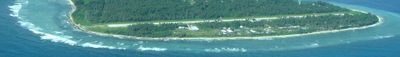
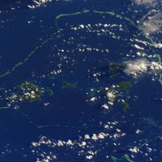
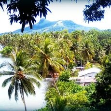
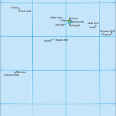
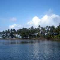
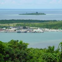
The Federated States of Micronesia is an island nation in the western Pacific, spread across six hundred seven islands distributed among the states of Yap, Chuuk, Pohnpei, and Kosrae, with 702 square kilometers (271 square miles) of land area north of the equator. The islands sit within western Pacific waters with extensive coral reefs and tropical vegetation.

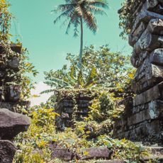
Micronesian seafarers settled the islands more than three thousand years ago, establishing complex societies. Spanish colonization in the sixteenth century was followed by German and Japanese administration before the territory came under American trusteeship after World War II and gained independence through the Compact of Free Association in 1986.

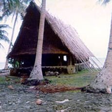
The four states preserve distinct cultural traditions including stone money systems on Yap, sophisticated navigation skills between atolls, and centuries-old cultivation methods for sakau, a ceremonially used pepper plant. More than thirty different languages are spoken across the archipelago, each with its own heritage and traditional stories.

International flights reach Pohnpei and Yap through Guam, while domestic flights connect the four states. The U.S. dollar serves as official currency. The dry season from December through April offers more comfortable travel conditions than the rainy period from May through November. Visitors should handle beachwear respectfully outside bathing areas.

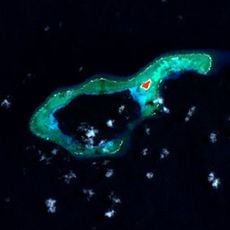
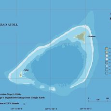
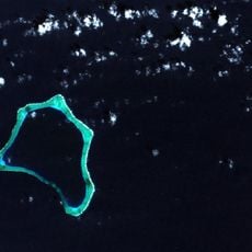
More than two thousand small coral formations surround the inhabited islands, many remaining in an untouched state. Local navigators continue using traditional wave patterns and star charts for journeys between atolls, knowledge passed orally through generations.

The community of curious travelers

AroundUs brings together thousands of curated places, local tips, and hidden gems, enriched daily by 60,000 contributors worldwide.

Start exploring
Inception
1947
Capital city
Palikir
Part of
Micronesia
Shares border with
United States, Palau, Papua New Guinea
Website
GPS coordinates
7.37375,150.41733
Latest update
December 14, 2025 17:58
Around this place
Nan Madol
Micronesia (Federated States of)

Nan Madol

876.3 km
Chuuk Lagoon
Micronesia (Federated States of)

Chuuk Lagoon

145.5 km
Micronesia (Federated States of)

Kimiuo Aisek Memorial Museum

157.6 km
Micronesia (Federated States of)

Xavier High School, Micronesia

162.5 km
Piagailoe
Micronesia (Federated States of)

Piagailoe

455.5 km
Micronesia (Federated States of)

Kosrae State Museum

1411.5 km
Olimarao
Micronesia (Federated States of)

Olimarao

503.1 km
Micronesia (Federated States of)

Japanese Lighthouse

137.7 km
Micronesia (Federated States of)

Japanese Shrine

862.2 km
Minto Reef
Micronesia (Federated States of)

Minto Reef

440.8 km
Micronesia (Federated States of)

Wiichen Men's Meetinghouse

160.8 km
Micronesia (Federated States of)

Japanese Army Headquarters

161.3 km
Micronesia (Federated States of)

Tonotan Guns and Caves

158.1 km
Rull Men's Meetinghouse
Micronesia (Federated States of)

Rull Men's Meetinghouse

1374.3 km
Tonnachau Mountain
Micronesia (Federated States of)

Tonnachau Mountain

158.4 km
Micronesia (Federated States of)

And Atoll

835 km
Micronesia (Federated States of)

Fauba Archaeological Site

132.8 km
Micronesia (Federated States of)

Immaculate Heart of Mary Cathedral

160 km
Micronesia (Federated States of)

Mount Finkol

1409.9 km
Lamolior
Micronesia (Federated States of)

Lamolior

472.9 km
Micronesia (Federated States of)

Japanese Artillery Road and Pohndolap Area

859.8 km
Micronesia (Federated States of)

Chief Agriculturist House

862 km
Micronesia (Federated States of)

Japanese Elementary School for Ponapean Children

862 km
District des autres îles de Pohnpei
Micronesia (Federated States of)

District des autres îles de Pohnpei

778.1 km
Micronesia (Federated States of)

Mount Teroken

158.2 km
Micronesia (Federated States of)

Temwetemwensekir

859.4 km
Micronesia (Federated States of)

Winimas

129.7 km
Micronesia (Federated States of)

Namoluk Atoll

341.8 km
Show the full map
« Federated States of Micronesia - Island country in western Pacific Ocean, Micronesia » is provided by Around Us (aroundus.com). Images and texts are derived from Wikimedia project under a Creative Commons license. You are allowed to copy, distribute, and modify copies of this page, under the conditions set by the license, as long as this note is clearly visible.

Discover hidden gems everywhere you go!

From secret cafés to breathtaking viewpoints, skip the crowded tourist spots and find places that match your style. Our app makes it easy with voice search, smart filtering, route optimization, and insider tips from travelers worldwide. Download now for the complete mobile experience.

Around Us App Screenshot

A unique approach to discovering new places

Le Figaro

All the places worth exploring

France Info

A tailor-made excursion in just a few clicks

20 Minutes

Around Us
Travel Guide & Maps
Download

Send to your phone

QR Code
1

Open the camera app on your mobile.

2

Point at the QR code with your camera. A notification will appear.

3

Tap the notification to open the link.