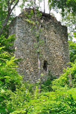
Burgruine Straßfried, Castle ruin in Thörl-Maglern, Austria.
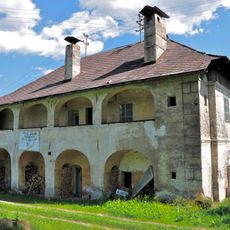
Burgruine Straßfried is a fortress ruin on a rocky ridge near the Austrian-Italian border, with steep northern slopes and gentler southern inclines. The site contains a rectangular courtyard roughly 50 meters long and 15 meters wide, enclosed by ring walls connected to a keep at the eastern end.
Bishops of Bamberg built this fortification in the first half of the 13th century, with its first recorded mention appearing in 1279 as Castrum Strazvrid. The structure suffered major damage from French forces during the Napoleonic Wars in 1797.
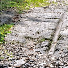
The stonework visible today reflects medieval construction methods, with carefully cut blocks combined with rough stone layers forming the fortress walls. These building techniques remain visible in the remaining structures.
The site requires sure footing and proper footwear, as the ruin sits on uneven ground with steep slopes. Visitors should come prepared for changing weather conditions and allow time to explore the structure and surroundings at a comfortable pace.
Only the eastern tower survives from the original twin-tower design, as the western tower was lost to the 1797 destruction by French forces. This asymmetry serves as a visible reminder of the violence that reached this border location.
Location: Thörl-Maglern
Location: Arnoldstein
Inception: 1279
Address: Maglern
GPS coordinates: 46.54970,13.66080
Latest update: December 9, 2025 20:24
Arnoldstein Abbey
3.7 km
Pfarrkirche Thörl-Maglern
1.3 km
Schrotturm Arnoldstein
2.5 km
Kreuzkapelle Arnoldstein
4.1 km
Evangelische Pfarrkirche Arnoldstein
3.2 km
Evangelische Auferstehungskirche in Arnoldstein
3.3 km
Filialkirche hl. Cyriacus, Hohenthurn
942 m
Filialkirche Seltschach
3.5 km
Evangelischer Friedhof mit Kapelle
3.5 km
Pfarrkirche Sankt Lambert
3.8 km
Friedhof mit drei Kapellen
3.1 km
Pfarrkirche Mariä Namen, Göriach, Hohenthurn
3.7 km
Ehem. Filialkirche hl. Maria
2.6 km
Station building Thörl-Maglern
1.4 km
Austria Italy border crossing #2442
2.3 km
Bildstock in Dreulach
3.4 km
Pfarrhof Göriach, Hohenthurn
3.8 km
Befestigung Zagrad bei Draschitz
2.7 km
Gailitzbrücke
2.4 km
Gailitzbrücke
2.4 km
Ehem. Gewerkenhaus Wrolch
2.2 km
Alte Poststraße
976 m
Zolldienst- und Wohngebäude
1.2 km
Befestigte Höhensiedlung Förker Laasriegel
4.6 km
Heimatmuseum Arnoldstein
3.6 km
Ehem. Forsthaus
1.9 km
Spätantike Höhensiedlung Hoischhügel
1.4 km
Greißlermuseum
1.9 kmVisited this place? Tap the stars to rate it and share your experience / photos with the community! Try now! You can cancel it anytime.
Discover hidden gems everywhere you go!
From secret cafés to breathtaking viewpoints, skip the crowded tourist spots and find places that match your style. Our app makes it easy with voice search, smart filtering, route optimization, and insider tips from travelers worldwide. Download now for the complete mobile experience.
A unique approach to discovering new places❞
— Le Figaro
All the places worth exploring❞
— France Info
A tailor-made excursion in just a few clicks❞
— 20 Minutes