
Bildstock, bildstock, Rotmarmor, 17. Jahrhundert; westlich unterhalb von Schneckenberg
Location: Traunreut
Address: Mitterau
GPS coordinates: 47.96173,12.57416
Latest update: November 19, 2025 05:06
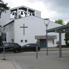
Pauluskirche
1.4 km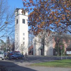
Zum Heiligsten Erlöser
1.4 km
Privatkapelle
1.7 km
Cultural heritage D-1-8041-0074 in Traunreut
667 m
Cultural heritage D-1-8041-0091 in Traunreut
788 m
Katholische Pfarrkirche St. Georg
1.3 km
Bauernhaus mit Flachsatteldach und Hochlaube
872 m
Bildstock
97 m
Cultural heritage D-1-8041-0253 in Traunreut
1.3 km
Bundwerkstadel
1.3 km
Cultural heritage D-1-8041-0075 in Traunreut
674 m
Wohnteil des ehem. Bauernhauses
1.4 km
Getreidekasten
849 m
Schuppen Weisbrunn 4 in Traunreut
863 m
Dorfschmiede
890 m
Kapelle
1.4 km
Stattliches Bauernhaus mit Blockbau-Obergeschoss
855 m
Schuppen Bräubergstraße 1 in Traunreut
1.3 km
Ehem. Kleinbauernhaus
713 m
Scheune Weisbrunn 3 in Traunreut
882 m
Bildstock
1.3 km
Pfarrhaus
1.3 km
Ehem. Bauernhaus mit Blockbau-Obergeschoss
1.4 km
Wegkapelle
34 m
Scheune Weisbrunn 11 in Traunreut
845 m
Work of art, statue
1.4 km
Mahnmahl
1.4 km
Wayside cross
543 mReviews
Visited this place? Tap the stars to rate it and share your experience / photos with the community! Try now! You can cancel it anytime.
Discover hidden gems everywhere you go!
From secret cafés to breathtaking viewpoints, skip the crowded tourist spots and find places that match your style. Our app makes it easy with voice search, smart filtering, route optimization, and insider tips from travelers worldwide. Download now for the complete mobile experience.

A unique approach to discovering new places❞
— Le Figaro
All the places worth exploring❞
— France Info
A tailor-made excursion in just a few clicks❞
— 20 Minutes