
Bundwerkstadel, forsthof; Südflügel des Bauernhofes, mit Gitterbundwerk und zwei überbauten Getreidekästen, bezeichnet mit 1868
Location: Burgkirchen an der Alz
Address: Forsthof 26
GPS coordinates: 48.15059,12.73635
Latest update: November 12, 2025 14:00
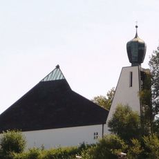
Dreifaltigkeitskirche (Burgkirchen an der Alz)
1.7 km
Flurkapelle
1.1 km
Wegkapelle
408 m
Wegkapelle
740 m
Weilerkapelle
987 m
Cultural heritage D-1-7842-0158 in Burgkirchen an der Alz
1.6 km
Cultural heritage D-1-7842-0020 in Burgkirchen an der Alz
915 m
Kirche
1.7 km
Nebengebäude Peterhof 24 in Burgkirchen an der Alz
1 km
Cultural heritage D-1-7842-0022 in Burgkirchen an der Alz
1.3 km
Einzelgarage Eichendorffring 12 in Burgkirchen an der Alz
1.7 km
Bauernhaus Kollmann a.Bach 31 in Burgkirchen an der Alz
1.3 km
Bildstock
946 m
Pestkreuz
1.6 km
Bundwerkstadel
66 m
Gitterbundwerkstadel
809 m
Windrad, auf hohem, eisernem Unterbau, wohl gegen 1900
1.5 km
Wohnhaus
1 km
Ehemaliges Kleinbauernhaus
1.6 km
Bildstock
1.5 km
Bauernhaus
1.3 km
Stadel
976 m
Nebengebäude Riedl 48 in Burgkirchen an der Alz
821 m
Gasthaus
1.7 km
Schuppen Riedl 48 in Burgkirchen an der Alz
823 m
Saturn (Planetenweg Burgkirchen)
1.7 km
Wayside cross, Christianity
1.1 km
Wayside cross
1.6 kmReviews
Visited this place? Tap the stars to rate it and share your experience / photos with the community! Try now! You can cancel it anytime.
Discover hidden gems everywhere you go!
From secret cafés to breathtaking viewpoints, skip the crowded tourist spots and find places that match your style. Our app makes it easy with voice search, smart filtering, route optimization, and insider tips from travelers worldwide. Download now for the complete mobile experience.

A unique approach to discovering new places❞
— Le Figaro
All the places worth exploring❞
— France Info
A tailor-made excursion in just a few clicks❞
— 20 Minutes