Stadel, bundwerkstadel mit Flachsatteldach, 1819, mit eingebautem Getreidekasten von 1693 (1698?), sowie Bienenkasten und Taubenschlägen
Location: Söchtenau
Address: Innthal 17
GPS coordinates: 47.89875,12.25194
Latest update: November 13, 2025 23:35

Katholische Filialkirche St. Petrus
1.7 km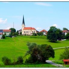
St. Peter
1.3 km
LSG Moor- und Tallandschaften bei Söchtenau
1 km
Cultural heritage D-1-8039-0152 in Söchtenau
1.3 km
Stadel
1.3 km
Waschhaus Dorfstraße 1 in Söchtenau
1.4 km
Cultural heritage D-1-8039-0072 in Bad Endorf
1.7 km
Stadel
68 m
Stadel
838 m
Stadel
1.5 km
Wegkapelle
1.6 km
Zugehöriger Bundwerkstadel
1.4 km
Ehem. Schulhaus
1.3 km
Scenic viewpoint
1.2 km
Memorial, war memorial
1.3 km
Wayside cross
1.7 km
Wayside cross
1.5 km
Wayside cross
1.7 km
Wayside cross
1.3 km
Wayside cross
1.5 km
Scenic viewpoint
1.5 km
Wayside cross
1.7 km
Josef Pollinger 1897
1.5 km
Wayside shrine
1.5 km
Christianity, wayside cross
1.6 km
Wayside cross
1.3 km
Wayside cross
782 m
Wayside cross
532 mReviews
Visited this place? Tap the stars to rate it and share your experience / photos with the community! Try now! You can cancel it anytime.
Discover hidden gems everywhere you go!
From secret cafés to breathtaking viewpoints, skip the crowded tourist spots and find places that match your style. Our app makes it easy with voice search, smart filtering, route optimization, and insider tips from travelers worldwide. Download now for the complete mobile experience.

A unique approach to discovering new places❞
— Le Figaro
All the places worth exploring❞
— France Info
A tailor-made excursion in just a few clicks❞
— 20 Minutes