Stadel, bundwerkstadel mit Flachsatteldach, 1. Hälfte 19. Jh
Location: Pfaffing
Address: Oed 5
GPS coordinates: 48.06689,12.11458
Latest update: November 9, 2025 11:33
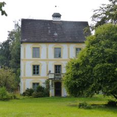
Schloss Brandstätt
1.3 km
Cultural heritage D-1-7938-0089 in Pfaffing (Landkreis Rosenheim)
319 m
Cultural heritage D-1-7938-0105 in Edling
1.3 km
Cultural heritage D-1-7938-0053 in Edling
960 m
Toteiskessel NW von Oed
307 m
Cultural heritage D-1-7938-0123 in Pfaffing (Landkreis Rosenheim)
1.4 km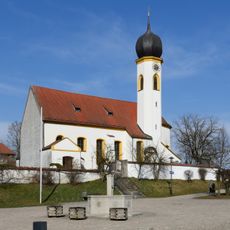
St. Katharina
1.4 km
Parallelhof
1.2 km
Getreidekasten Nodern 85 in Pfaffing (Landkreis Rosenheim)
898 m
Bauernhof
923 m
Stadel
1.8 km
Bauernhaus
624 m
Hofkapelle
420 m
Bildstock
1.1 km
Wegkreuz aus Granit
1.6 km
Scheune Wolfrain 2 in Edling
1.2 km
Breche In Wolfrain in Edling
1.3 km
Brechhütte
1.8 km
Bauernhaus
677 m
Bauernhaus
644 m
Wayside cross
1.6 km
Wayside cross
1.3 km
Wayside shrine
1.3 km
Wayside cross
1.6 km
Wayside cross
1.2 km
Wayside cross
1.2 km
Wayside cross
1.5 km
Franzosenkreuz
1.8 kmReviews
Visited this place? Tap the stars to rate it and share your experience / photos with the community! Try now! You can cancel it anytime.
Discover hidden gems everywhere you go!
From secret cafés to breathtaking viewpoints, skip the crowded tourist spots and find places that match your style. Our app makes it easy with voice search, smart filtering, route optimization, and insider tips from travelers worldwide. Download now for the complete mobile experience.

A unique approach to discovering new places❞
— Le Figaro
All the places worth exploring❞
— France Info
A tailor-made excursion in just a few clicks❞
— 20 Minutes