Kreuz, gusseisern, Ende 19. Jahrhundert; am Weg zwischen Reischach und Petzlberg
Location: Reischach
Address: Flur Petzlberg
GPS coordinates: 48.28886,12.73472
Latest update: November 19, 2025 01:37
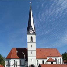
St. Martin
609 m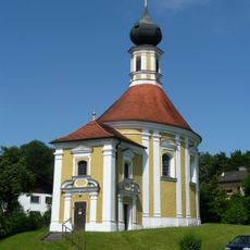
St. Anton von Padua
855 m
Kapelle, sogenannte Marienkapelle
963 m
Kapelle, sogenannte Sedlmairkapelle
635 m
Scheune Petzlberg 6 in Reischach
480 m
Einfirsthof, sogenanntes Mitternhäusl
409 m
Cultural heritage D-1-7742-0041 in Reischach
1 km
Ehemaliges Kleinbauernhaus, sogenanntes „Fürstengütl“
732 m
Vierseithof „Beim Bauer“
997 m
Hütte
445 m
Stadel
528 m
Cultural heritage D-1-7742-0219 in Reischach
856 m
Cultural heritage D-1-7742-0197 in Reischach
609 m
Bauernhaus
912 m
Wegkreuz
1.2 km
Ehemaliges Bauernhaus
455 m
Friedhofsmauer Kirchplatz 1 in Reischach
619 m
Wayside cross
1.2 km
Wayside cross
1.1 km
Wayside cross
1.6 km
Scenic viewpoint
1.6 km
Wayside cross
560 m
Wayside cross
509 m
Wayside cross
1.6 km
Wayside shrine
1.7 km
Wayside cross
525 m
Wayside cross
379 m
Wayside cross
771 mReviews
Visited this place? Tap the stars to rate it and share your experience / photos with the community! Try now! You can cancel it anytime.
Discover hidden gems everywhere you go!
From secret cafés to breathtaking viewpoints, skip the crowded tourist spots and find places that match your style. Our app makes it easy with voice search, smart filtering, route optimization, and insider tips from travelers worldwide. Download now for the complete mobile experience.

A unique approach to discovering new places❞
— Le Figaro
All the places worth exploring❞
— France Info
A tailor-made excursion in just a few clicks❞
— 20 Minutes