
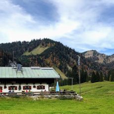
Almhütte „Steffelbauer“
Almhütte „Steffelbauer“, zweigeschossiger teils verputzter Bruchsteinbau mit verschindeltem Blockbau-Obergeschoss und Flachsatteldach, 2. Hälfte 18. Jahrhundert
Location: Lenggries
Address: Roßsteinalm
GPS coordinates: 47.63697,11.67098
Latest update: November 24, 2025 03:28
Schwarzentennalm
1.4 km
Hoch Platte
485 m
Sonnbergalm
1.1 km
Kapelle und Kriegergedächtnisstätte
2.1 km
Kapelle
2 km
Almhütte „Zum Altanderl“
15 m
Forsthütte
2 km
Almhütte „Aschenlocher“
1.4 km
Alm
1.3 km
Almhütte „Zum Oberjäger“
30 m
Alm
1.5 km
Almhütte
1.8 km
Almhütte „Lasslbauer“
48 m
Almhütte „Asenbauer“
1.5 km
Buchstein
764 m
Catholic church building, wayside cross, Christianity
1.5 km
Wayside shrine
1.1 km
Wayside cross
1.6 km
Sonnberg Alm
1.2 km
Hans Peter Worbs
2 km
Memorial, war memorial
1.9 km
Stele, memorial
710 m
Wayside cross
708 m
Wayside cross, Christianity
2.1 km
Waterfall
1.6 km
Schwarzenbach-Wasserfall
1.8 km
Waterfall
1.3 km
Waterfall
2 kmReviews
Visited this place? Tap the stars to rate it and share your experience / photos with the community! Try now! You can cancel it anytime.
Discover hidden gems everywhere you go!
From secret cafés to breathtaking viewpoints, skip the crowded tourist spots and find places that match your style. Our app makes it easy with voice search, smart filtering, route optimization, and insider tips from travelers worldwide. Download now for the complete mobile experience.

A unique approach to discovering new places❞
— Le Figaro
All the places worth exploring❞
— France Info
A tailor-made excursion in just a few clicks❞
— 20 Minutes