
Zugehöriger Riegelbundwerkstadel
Zugehöriger Riegelbundwerkstadel, gegen Mitte 19. Jahrhundert
Location: Kumhausen
Address: Höhenberg, Haus Nr. 27
GPS coordinates: 48.50058,12.19678
Latest update: November 24, 2025 07:57

St. Ulrich
1.6 km
St. Laurentius
1.6 km
St. Maria (Götzdorf)
1.4 km
Kapelle
1.5 km
Cultural heritage D-2-7439-0315 in Kumhausen
1.6 km
Cultural heritage D-2-7539-0184 in Kumhausen
1.6 km
Cultural heritage D-2-7439-0267 in Kumhausen
1.5 km
Haus Nr. 8 -
1.5 km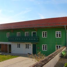
Ehemaliges Bauernhaus
1.6 km
Cultural heritage D-2-7539-0180 in Kumhausen
1.4 km
Cultural heritage D-2-7539-0065 in Kumhausen
1.6 km
Cultural heritage D-2-7439-0164 in Kumhausen
1 km
Wohnstallhaus eines ehemaligen Dreiseithofs
1.4 km
Cultural heritage D-2-7439-0165 in Kumhausen
928 m
Friedhofskapelle Kirchplatz 1 1/2 in Kumhausen
1.6 km
Wohnstallhaus und Backhaus
1.5 km
Cultural heritage D-2-7439-0179 in Kumhausen
1.7 km
Cultural heritage D-2-7439-0169 in Kumhausen
2.1 km
Cultural heritage D-2-7439-0163 in Kumhausen
1.1 km
Backhaus Badstauden 6 in Kumhausen
1.5 km
Cultural heritage D-2-7539-0070 in Kumhausen
1.9 km
Cultural heritage D-2-7439-0170 in Kumhausen
1.3 km
Friedhofsmauer Kirchplatz 1 1/2 in Kumhausen
1.6 km
Zentralbau Götzdorf 9 in Kumhausen
1.4 km
Wayside cross
1 km
Memorial
1.6 km
Wayside cross
1.6 km
Wayside cross
1.8 kmReviews
Visited this place? Tap the stars to rate it and share your experience / photos with the community! Try now! You can cancel it anytime.
Discover hidden gems everywhere you go!
From secret cafés to breathtaking viewpoints, skip the crowded tourist spots and find places that match your style. Our app makes it easy with voice search, smart filtering, route optimization, and insider tips from travelers worldwide. Download now for the complete mobile experience.

A unique approach to discovering new places❞
— Le Figaro
All the places worth exploring❞
— France Info
A tailor-made excursion in just a few clicks❞
— 20 Minutes