
Wohnhaus, building in Wallenfels, Upper Franconia, Germany
Location: Wallenfels
Address: Mühlgrabenstraße 17
GPS coordinates: 50.26646,11.47547
Latest update: March 15, 2025 00:39


St. Thomas
143 m
Burg Waldenfels
299 m
Geuserberg
2.1 km
Kapelle
284 m
Bildstock (Wallenfels, Schützenstraße)
669 m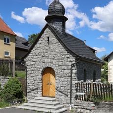
Kapelle
2.6 km
Kapelle
2.4 km
Kapelle
434 m
Wegkapelle
907 m
Cultural heritage D-4-76-184-17 in Wallenfels
198 m
Cultural heritage D-4-76-184-9 in Wallenfels
58 m
Rathaus (Wallenfels)
244 m
Bildstock
1.7 km
Cultural heritage D-4-76-184-13 in Wallenfels
308 m
Wohnhaus
284 m
Cultural heritage D-4-76-184-23 in Wallenfels
513 m
Verbandsschule Wallenfels
949 m
Bildstock
235 m
Schulgebäude
218 m
Katholisches Pfarrhaus
177 m
Wohnhaus
357 m
Rodachbrücke
366 m
Forsthaus
351 m
Cultural heritage D-4-76-184-2 in Wallenfels
365 m
Wohnstallhaus
2.6 km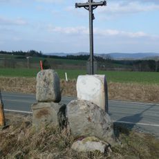
Marter
2.8 km
Wohnhaus
309 m
Fünfwundenkreuz
1.7 kmReviews
Visited this place? Tap the stars to rate it and share your experience / photos with the community! Try now! You can cancel it anytime.
Discover hidden gems everywhere you go!
From secret cafés to breathtaking viewpoints, skip the crowded tourist spots and find places that match your style. Our app makes it easy with voice search, smart filtering, route optimization, and insider tips from travelers worldwide. Download now for the complete mobile experience.

A unique approach to discovering new places❞
— Le Figaro
All the places worth exploring❞
— France Info
A tailor-made excursion in just a few clicks❞
— 20 Minutes