, bundwerkstadel (Südflügel des Vierseithofes), bezeichnet mit dem Jahr 1797, mit Bemalung an der östlichen Giebelseite; Stallstadel (Ostflügel) mit Bundwerk und Medaillonmalerei, bezeichnet mit dem Jahr 1797
Location: Tittmoning
Address: Niederstockham 1
GPS coordinates: 48.00459,12.76946
Latest update: November 20, 2025 13:09
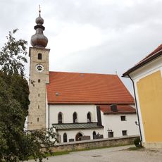
St. Vitus
1.5 km
Veitlmaier-Kapelle
1.3 km
Cultural heritage D-1-7942-0074 in Tittmoning
1.5 km
Dorfplatz 19, Tittmoning
1.5 km
St. Nikolaus
1.1 km
Getreidekasten
1.1 km
Cultural heritage D-1-7942-0209 in Tittmoning
1.5 km
Cultural heritage D-1-7942-0187 in Tittmoning
1.1 km
Kornspeicher Harmoning 8 in Tittmoning
971 m
Friedhofsmauer Dorfplatz 23; Dorfplatz 25 in Tittmoning
1.5 km
Stallstadel Niederstockham 1 in Tittmoning
18 m
Großer Bundwerkstadel
1.2 km
Vierseithof
1.5 km
Hofkapelle Harmoning 8 in Tittmoning
977 m
Friedhofsmauer Hof 3 in Tittmoning
1.1 km
Scheune Moosen 1 in Tittmoning
654 m
Stall Enhub 1 in Fridolfing
1.5 km
Vierseithof Enhub 1 in Fridolfing
1.5 km
Wayside cross
571 mReviews
Visited this place? Tap the stars to rate it and share your experience / photos with the community! Try now! You can cancel it anytime.
Discover hidden gems everywhere you go!
From secret cafés to breathtaking viewpoints, skip the crowded tourist spots and find places that match your style. Our app makes it easy with voice search, smart filtering, route optimization, and insider tips from travelers worldwide. Download now for the complete mobile experience.

A unique approach to discovering new places❞
— Le Figaro
All the places worth exploring❞
— France Info
A tailor-made excursion in just a few clicks❞
— 20 Minutes