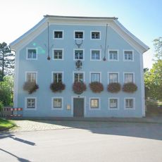
Feldkreuz, flaches Steinkreuz, Anfang 19. Jahrhundert
Location: Teisendorf
Address: Leitenfeld
GPS coordinates: 47.84009,12.81288
Latest update: November 24, 2023 20:01

Postamt
1.2 km
Wegkapelle
3 m
Kornspeicher Traunsteiner Straße 23 1/2 in Teisendorf
1 km
Einfirsthof
1.2 km
Bauernhaus, Einfirstanlage
331 m
Wohnteil des Bauernhauses
1.1 km
Wohnteil des ehemaligen Kleinbauernhauses
1.1 km
Wohnteil des ehemaligen Bauernhauses
378 m
Ehemals Schmiede
1.1 km
Hofkapelle Babing 3 in Teisendorf
1.1 km
Wohnteil des Bauernhofs, sogenannt beim Saliterer
1.1 km
Ehemals Bauernhof mit Widerkehr
366 m
Wohnteil des Bauernhauses
344 m
Gut Forstamtsplatz 1 in Teisendorf
1.2 km
Ehemals Gut Plachentrum, dann Salzburgisches Pfleggericht und Forstamt
1.1 km
Kornspeicher Babing 3 1/2 in Teisendorf
1.1 km
Troadkasten,
1.1 km
Wohnteil eines Bauernhauses
1.1 km
Ehemals Kleinbauernhof
467 m
Brunnmeister-Kreuz und Totentafeln
1.1 km
Wayside shrine, Christianity
865 m
Mariensäule
1.1 km
Totentafeln
468 m
Moosen Kreuz und Totentafeln
512 m
Wayside cross
339 m
Wayside cross
807 m
Freidlinger Bach
172 m
Wayside cross
8 mReviews
Visited this place? Tap the stars to rate it and share your experience / photos with the community! Try now! You can cancel it anytime.
Discover hidden gems everywhere you go!
From secret cafés to breathtaking viewpoints, skip the crowded tourist spots and find places that match your style. Our app makes it easy with voice search, smart filtering, route optimization, and insider tips from travelers worldwide. Download now for the complete mobile experience.

A unique approach to discovering new places❞
— Le Figaro
All the places worth exploring❞
— France Info
A tailor-made excursion in just a few clicks❞
— 20 Minutes