
Bildstock, niedriger Steinpfeiler mit Bildnische und verschindeltem Zeltdach, wohl 19. Jahrhundert; südöstlich der Kapelle
Location: Taching am See
Address: Gessenhausen 7
GPS coordinates: 47.98452,12.76043
Latest update: November 11, 2025 18:07
Turmhügel Gessenhausen
1.1 km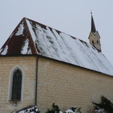
St. Coloman
1.6 km
Privatkapelle
75 m
Schmidbauern-Kapelle
1.5 km
Wegkapelle
1.7 km
Wegkapelle
276 m
Cultural heritage D-1-8042-0045 in Taching am See
435 m
Cultural heritage D-1-8042-0239 in Taching am See
851 m
Cultural heritage D-1-8042-0046 in Taching am See
1.1 km
Cultural heritage D-1-8042-0008 in Fridolfing
1 km
Cultural heritage D-1-8042-0177 in Taching am See
1.6 km
Bauernhaus mit doppelter Widerkehr
1.7 km
Kornspeicher Harmoning 8 in Tittmoning
1.7 km
Cultural heritage D-1-8042-0121 in Waging am See
1.5 km
Einfirsthof
244 m
Wegkreuz
517 m
Hofkapelle Harmoning 8 in Tittmoning
1.7 km
Wohnteil des Bauernhauses
219 m
Wohnteil am Althof des Einödhofes
1.1 km
Bauernhaus Hohenbergham 8 in Fridolfing
1.7 km
Scenic viewpoint
1.6 km
Bench, scenic viewpoint
1.5 km
Wayside cross
853 m
Wayside cross
517 m
Wayside cross
136 mReviews
Visited this place? Tap the stars to rate it and share your experience / photos with the community! Try now! You can cancel it anytime.
Discover hidden gems everywhere you go!
From secret cafés to breathtaking viewpoints, skip the crowded tourist spots and find places that match your style. Our app makes it easy with voice search, smart filtering, route optimization, and insider tips from travelers worldwide. Download now for the complete mobile experience.

A unique approach to discovering new places❞
— Le Figaro
All the places worth exploring❞
— France Info
A tailor-made excursion in just a few clicks❞
— 20 Minutes