
Getreidekasten, hörafing; erdgeschossiger Blockbau, bezeichnet mit 1555, in jüngerem Stadel eingebaut
Location: Teisendorf
Address: Staufenstraße 11; Staufenstraße 13
GPS coordinates: 47.84612,12.87618
Latest update: November 20, 2025 22:58
Mariä Himmelfahrt (Weildorf)
1.8 km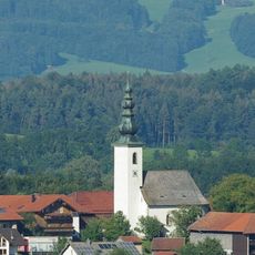
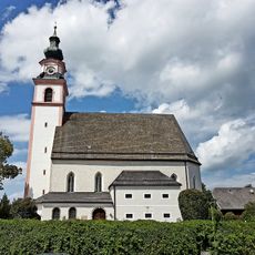
St. Nikolaus
1.5 km
Feldkapelle
601 m
Cultural heritage D-1-8143-0013 in Ainring
1.7 km
Cultural heritage D-1-8143-0171 in Teisendorf
346 m
Cultural heritage D-1-8143-0079 in Teisendorf
975 m
Ehemals Wassermühle, sogenannte Kumpfmühle
981 m
LSG Oberlauf der Kleinen Sur
1.3 km
Bildstock Reut in Teisendorf
1.7 km
Cultural heritage D-1-8143-0086 in Teisendorf
1.3 km
Cultural heritage D-1-8143-0088 in Teisendorf
1.8 km
Wegkreuz mit Kreuzigungsgruppe
922 m
Cultural heritage D-1-8143-0191 in Ainring
1.5 km
Obergeschoss des sogenannten Weberhäusl
787 m
Ehemaliges Bauernhaus
1.5 km
Cultural heritage D-1-8143-0280 in Ainring
1.8 km
Wohnteil des Bauernhauses
885 m
Cultural heritage D-1-8143-0173 in Ainring
1.4 km
Ehemals Bauernhof
1.8 km
Wohnteil des Bauernhauses
1.8 km
Türgewände
1.8 km
Bildstock Leitenholz in Teisendorf
1.7 km
Cultural heritage D-1-8143-0176 in Teisendorf
1.7 km
Gasthof Huber
1.7 km
Bildstock Nähe Teisendorfer Straße in Teisendorf
1.7 km
Bildstock Leitenholz in Teisendorf
1.7 km
Wayside cross
1.6 km
Wayside cross
1.6 kmReviews
Visited this place? Tap the stars to rate it and share your experience / photos with the community! Try now! You can cancel it anytime.
Discover hidden gems everywhere you go!
From secret cafés to breathtaking viewpoints, skip the crowded tourist spots and find places that match your style. Our app makes it easy with voice search, smart filtering, route optimization, and insider tips from travelers worldwide. Download now for the complete mobile experience.

A unique approach to discovering new places❞
— Le Figaro
All the places worth exploring❞
— France Info
A tailor-made excursion in just a few clicks❞
— 20 Minutes