
Bildstock, seidlalber; aus Tuff mit geschweifter Oberkante, bezeichnet mit dem Jahr 1791; an der Straße Schmidhub-Oberenfeln; zu Haus Nr. 1 gehörig
Location: Kastl
Address: Seidlalber 1
GPS coordinates: 48.17985,12.69557
Latest update: November 24, 2023 20:01
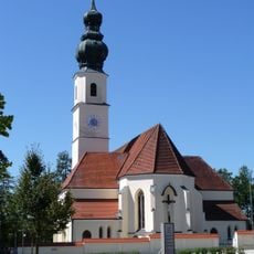
Mariä Himmelfahrt
1.7 km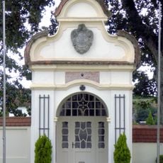
Kriegergedächtniskapelle
1.7 km
Kapelle, sogenannte ''Erharten-Kapelle''
502 m
Tiefbrunnen Niedersaß 1; Niedersaß 2; Niedersaß 3 in Kastl (Landkreis Altötting)
950 m
Cultural heritage D-1-7842-0143 in Kastl (Landkreis Altötting)
1.7 km
Cultural heritage D-1-7842-0145 in Kastl (Landkreis Altötting)
1.1 km
Pfarrkirche Altöttinger Straße 12; Altöttinger Straße 12a in Kastl (Landkreis Altötting)
1.7 km
Stadel, Gitterbundwerkstadel
1.5 km
Cultural heritage D-1-7842-0066 in Kastl (Landkreis Altötting)
1.2 km
Cultural heritage D-1-7842-0065 in Burgkirchen an der Alz
1.5 km
Gitterbundwerkstadel
1.3 km
Bauernhaus
1.2 km
Stadel
1.5 km
Bauernhaus
1.2 km
Getreidekasten
1.2 km
Getreidekasten
522 m
Hütte, Ostflügel des Vierseithofes
1.3 km
Cultural heritage D-1-7842-0054 in Kastl (Landkreis Altötting)
1.4 km
Cultural heritage D-1-7842-0093 in Burgkirchen an der Alz
1.4 km
Bundwerkstadel
1.2 km
Bundwerkstadel
1.2 km
Backofenhaus
951 m
Nebengebäude Pirach 10 in Kastl (Landkreis Altötting)
635 m
Vierseithof
626 m
Mariä Himmelfahrt
1.7 km
Stadel
626 m
Nebengebäude Zauner 1 in Kastl (Landkreis Altötting)
1.2 km
Wayside cross
1.7 kmReviews
Visited this place? Tap the stars to rate it and share your experience / photos with the community! Try now! You can cancel it anytime.
Discover hidden gems everywhere you go!
From secret cafés to breathtaking viewpoints, skip the crowded tourist spots and find places that match your style. Our app makes it easy with voice search, smart filtering, route optimization, and insider tips from travelers worldwide. Download now for the complete mobile experience.

A unique approach to discovering new places❞
— Le Figaro
All the places worth exploring❞
— France Info
A tailor-made excursion in just a few clicks❞
— 20 Minutes