Stadel, winkler a.Holz; mit bemaltem Bundwerk, Südflügel des Bauernhofes, bezeichnet mit dem Jahr 1857
Location: Kastl
Address: Winkler a.Holz 1
GPS coordinates: 48.21020,12.69102
Latest update: November 21, 2025 03:08
Mariä Himmelfahrt
1.7 km
Jetzkapelle
747 m
Pfarrhaus
1.6 km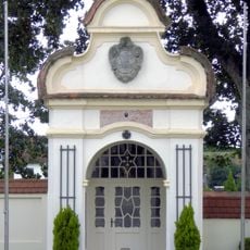
Kriegergedächtniskapelle
1.7 km
Wegkapelle
1.2 km
Wegkapelle, sogenannte Straßerkapelle
1.7 km
Cultural heritage D-1-7742-0205 in Kastl (Landkreis Altötting)
838 m
Amtsgericht Burghauser Straße 28; Traunsteiner Straße 1; Traunsteiner Straße 1a in Altötting
1.7 km
Cultural heritage D-1-7842-0143 in Kastl (Landkreis Altötting)
1.7 km
Pfarrhaus Schulstraße 2 in Kastl (Landkreis Altötting)
1.6 km
Amtsgericht Traunsteiner Straße 1a in Altötting
1.7 km
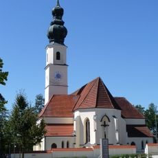
Pfarrkirche Altöttinger Straße 12; Altöttinger Straße 12a in Kastl (Landkreis Altötting)
1.7 km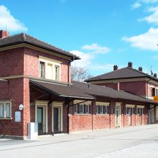
Bahnhof Altötting
1.7 km
Gitterbundwerk-Stadel
1.1 km
Bundwerkstadel
1.5 km
Amtsgericht
1.7 km
Pestkreuz
839 m
Mariä Himmelfahrt
1.7 km
Wayside shrine
1.2 km
Wayside cross
1.2 km
Wayside shrine, Christianity
1.1 km
Wayside cross
1.4 km
Wayside cross
290 m
Wayside shrine, Christianity
1.5 km
Wayside cross
1.2 km
Wayside cross
1.4 km
Pestkreuz
764 m
Wayside cross
423 mReviews
Visited this place? Tap the stars to rate it and share your experience / photos with the community! Try now! You can cancel it anytime.
Discover hidden gems everywhere you go!
From secret cafés to breathtaking viewpoints, skip the crowded tourist spots and find places that match your style. Our app makes it easy with voice search, smart filtering, route optimization, and insider tips from travelers worldwide. Download now for the complete mobile experience.

A unique approach to discovering new places❞
— Le Figaro
All the places worth exploring❞
— France Info
A tailor-made excursion in just a few clicks❞
— 20 Minutes