Pfarrhof, zweigeschossiger barocker Halbwalmdachbau mit Putzgliederung, 18. Jahrhundert; Hofummauerung, aus Bruchstein, 18. Jahrhundert
Location: Rechtmehring
Address: Stechlring 2
GPS coordinates: 48.12402,12.16051
Latest update: November 24, 2023 20:01
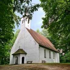
Mariä Heimsuchung
2 km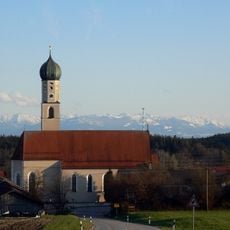
St. Korbinian
87 m
Gasthof Kirchenwirt
52 m
Toteiskessel NE von Höller
1.6 km
Bildstock
392 m
Cultural heritage D-1-7838-0131 in Rechtmehring
937 m
Cultural heritage D-1-7839-0098 in Rechtmehring
2 km
Bildstock
1.4 km
Bildstock
1.3 km
St. Andreas
930 m
Cultural heritage D-1-7838-0014 in Rechtmehring
792 m
Stadel
926 m
Cultural heritage D-1-7838-0129 in Rechtmehring
86 m
Bildstock
681 m
Stallstadel
1.6 km
Toteiskessel NW von Grub
2 km
Ehemaliges Gasthaus
808 m
Bildstock
2.1 km
Pfarrhof Gartenweg 3; Stechlring 2 in Rechtmehring
30 m
Wohnstallhaus
1.7 km
Wayside cross
1.6 km
Scenic viewpoint
1.9 km
Wayside shrine
1.8 km
Wayside cross
2 km
Wayside cross
2 km
Wayside cross
2 km
Wayside cross
1.6 km
Scenic viewpoint
1 kmReviews
Visited this place? Tap the stars to rate it and share your experience / photos with the community! Try now! You can cancel it anytime.
Discover hidden gems everywhere you go!
From secret cafés to breathtaking viewpoints, skip the crowded tourist spots and find places that match your style. Our app makes it easy with voice search, smart filtering, route optimization, and insider tips from travelers worldwide. Download now for the complete mobile experience.

A unique approach to discovering new places❞
— Le Figaro
All the places worth exploring❞
— France Info
A tailor-made excursion in just a few clicks❞
— 20 Minutes