
Ehemalige Mühle, wohnstallhaus, zweigeschossiger Massivbau mit Bundwerkgiebel und flach geneigtem Satteldach, bezeichnet mit dem Jahr 1827; angebauter, erneuerter Bundwerkstadel, bezeichnet mit dem Jahr 1832
Location: Kraiburg
Address: Flossinger Straße 10
GPS coordinates: 48.19798,12.48662
Latest update: November 13, 2025 18:51
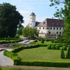
Schloss Guttenburg
1.5 km
Mariä Geburt
1.2 km
St. Michael
116 m
Ehemaliger Wirtschaftsteil des Gasthauses
63 m
Cultural heritage D-1-7740-0051 in Kraiburg am Inn
816 m
Grabmal Kirchweg 1 in Kraiburg am Inn
106 m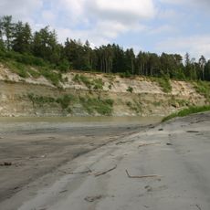
Prallhang des Inns NE von Heisting
1.6 km
Schloss Nähe Guttenburg; Schloßberg; Schloßweg in Kraiburg am Inn
1.5 km
Cultural heritage D-1-7840-0169 in Kraiburg am Inn
1.5 km
Schloss Guttenburg 18 in Kraiburg am Inn
1.5 km
Ehemaliger Brauereigasthof
1.5 km
Friedhofsmauer Kirchweg 1 in Kraiburg am Inn
110 m
Scheune Flossinger Straße 10 in Kraiburg am Inn
26 m
Cultural heritage D-1-7840-0194 in Kraiburg am Inn
109 m
Schloss Guttenburg 18 in Kraiburg am Inn
1.6 km
Marstall Guttenburg 18 in Kraiburg am Inn
1.5 km
Bildstock
1.4 km
Grabmal Kirchweg 1 in Kraiburg am Inn
102 m
Schlosspark Guttenburg 18 in Kraiburg am Inn
1.5 km
Golfclub Schloss Guttenburg
1.3 km
Heistinger Hang
1.6 km
Wayside cross
192 m
Wayside cross
872 m
Wayside cross
440 m
Christianity, wayside shrine
1.5 kmReviews
Visited this place? Tap the stars to rate it and share your experience / photos with the community! Try now! You can cancel it anytime.
Discover hidden gems everywhere you go!
From secret cafés to breathtaking viewpoints, skip the crowded tourist spots and find places that match your style. Our app makes it easy with voice search, smart filtering, route optimization, and insider tips from travelers worldwide. Download now for the complete mobile experience.

A unique approach to discovering new places❞
— Le Figaro
All the places worth exploring❞
— France Info
A tailor-made excursion in just a few clicks❞
— 20 Minutes