Stadel, südflügel eines Vierseithofs, stattlicher zweitenniger Ständerbohlenbau mit Flachsatteldach und aufwändigem Bundwerk, bezeichnet mit dem Jahr 1848; Windbrunnen, Stahlkonstruktion, 1921
Location: Taufkirchen
Address: Dunzmaier 1
GPS coordinates: 48.14946,12.46459
Latest update: November 13, 2025 13:34

Windbrunnen
1.1 km
Zuhaus
694 m
Hütte
2.4 km
Cultural heritage D-1-7840-0209 in Taufkirchen (Landkreis Mühldorf am Inn)
2.5 km
Cultural heritage D-1-7840-0205 in Taufkirchen (Landkreis Mühldorf am Inn)
2.9 km
Cultural heritage D-1-7840-0043 in Taufkirchen (Landkreis Mühldorf am Inn)
1.5 km
Kleinbauernhaus
2.5 km
Wegkapelle
687 m
Leichenhalle Pietenberg 5 in Taufkirchen
2.9 km
Immerwährende Hilfe Mariens
2.6 km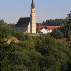
Mariä Himmelfahrt
2.9 km
Kapelle
2 km
Stadel
1.6 km
Versetzter Getreidekasten
2.1 km
St. Georg
2.5 km
Cultural heritage D-1-7840-0203 in Taufkirchen (Landkreis Mühldorf am Inn)
588 m
Getreidekasten
2.5 km
St. Jakobus
583 m
Stadel Dunzmaier 1 in Taufkirchen (Landkreis Mühldorf am Inn)
49 m
Stadel
1.6 km
Wayside cross
2.2 km
Christianity, wayside cross
1.3 km
Wayside cross
2.6 km
Wayside cross
1.2 km
Wayside cross
2.2 km
Wayside cross
2.5 km
Wayside shrine
2 km
Wayside cross
245 mReviews
Visited this place? Tap the stars to rate it and share your experience / photos with the community! Try now! You can cancel it anytime.
Discover hidden gems everywhere you go!
From secret cafés to breathtaking viewpoints, skip the crowded tourist spots and find places that match your style. Our app makes it easy with voice search, smart filtering, route optimization, and insider tips from travelers worldwide. Download now for the complete mobile experience.

A unique approach to discovering new places❞
— Le Figaro
All the places worth exploring❞
— France Info
A tailor-made excursion in just a few clicks❞
— 20 Minutes