
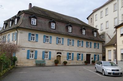
An der Stadtmühle 1, zweigeschossiger Sandsteinquaderbau mit Eckpilastern und Gurtgesims, Mansarddach, bezeichnet „1775“
Location: Höchstadt an der Aisch
Address: An der Stadtmühle 1
GPS coordinates: 49.70175,10.80400
Latest update: March 2, 2025 20:01

Altes Rathaus
156 m
Schillerplatz 1 (Höchstadt an der Aisch)
199 m
Obere Brauhausgasse 3
242 m
Am Kirchplatz 2
220 m
Brunnenhaus
183 m
Stadttor
178 m
Brückenstraße 9, Torpfeiler
116 m
Hauptstraße 8
178 m
Hauptstraße 10
202 m
Badgasse 2 (Höchstadt an der Aisch)
140 m
Schranne 4
138 m
Martersäule vor dem Schloss
101 m
Hauptstraße 7
180 m
Hauptstraße 4
188 m
Schloss Höchstadt
43 m
Schillerplatz 8
148 m
Marktplatz 2 (Höchstadt an der Aisch)
181 m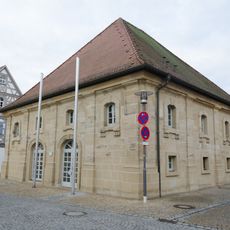
Obere Brauhausgasse 7 (Höchstadt an der Aisch)
278 m
Ehemaliges Amtsgericht
62 m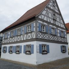
Am Brauhaus 1
278 m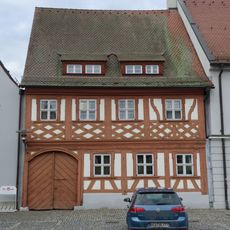
Marktplatz 4
203 m
Hauptstraße 6
182 m
Schillerplatz 2
214 m
Färbergasse 4
136 m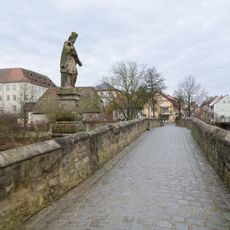
Alte Brücke über die Aisch
84 m
Marktplatz 5
220 m
Badgasse 7
120 m
Hauptstraße 3
159 mReviews
Visited this place? Tap the stars to rate it and share your experience / photos with the community! Try now! You can cancel it anytime.
Discover hidden gems everywhere you go!
From secret cafés to breathtaking viewpoints, skip the crowded tourist spots and find places that match your style. Our app makes it easy with voice search, smart filtering, route optimization, and insider tips from travelers worldwide. Download now for the complete mobile experience.

A unique approach to discovering new places❞
— Le Figaro
All the places worth exploring❞
— France Info
A tailor-made excursion in just a few clicks❞
— 20 Minutes