
Mittertennbau, blockbau, erste Hälfte 19. Jahrhundert, mit späterem Dach
Location: Bad Birnbach
Address: Obertattenbach 7
GPS coordinates: 48.46396,13.06267
Latest update: November 20, 2025 09:29
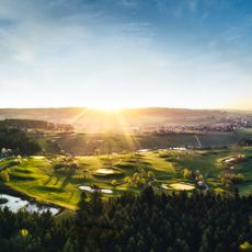
Bella Vista Golfpark Bad Birnbach
2 km
Katholische Pfarrkirche St. Pankratius
601 m
Kleine Kapelle
1.6 km
Kapelle
1.5 km
Ehemaliges Austragshaus mit Blockbau-Obergeschoss
975 m
Cultural heritage D-2-7544-0066 in Bad Birnbach
599 m
Rottaler Bauernhaus eines Vierseithofes, erstes Drittel 19. Jahrhundert
1.6 km
Rottaler Bauernhaus eines stattlichen Vierseithofes
1.2 km
Cultural heritage D-2-7544-0023 in Bad Birnbach
1.7 km
Bauernhaus eines Vierseithofes
1.4 km
Stall Schwertling 20 in Bad Birnbach
2.1 km
Bauernhaus eines Vierseithofes
1.5 km
Ehemaliges Bauernhaus
1.7 km
Einfirsthof
1 km
Bauernhaus eines Vierseithofes
125 m
Bauernhaus eines Vierseithofes
144 m
Bauernhaus eines Vierseithofes
2 km
Bauernhaus eines Vierseithofes
2.1 km
Kleinbauernhaus
460 m
Bauernhaus eines Vierseithofes
1.6 km
Kleinbauernhaus
1.1 km
Bauernhaus
957 m
Rottaler Bauernhaus eines Vierseithofes
1.1 km
Wohnhaus eines ehemaligen Vierseithofes
1.4 km
Remise Schwertling 20 in Bad Birnbach
2.1 km
Ehemaliges Bauernhaus in Blockbau
349 m
Remise Kynoten 1 in Bad Birnbach
1.2 km
Kornspeicher Obertattenbach 3 in Bad Birnbach
124 mReviews
Visited this place? Tap the stars to rate it and share your experience / photos with the community! Try now! You can cancel it anytime.
Discover hidden gems everywhere you go!
From secret cafés to breathtaking viewpoints, skip the crowded tourist spots and find places that match your style. Our app makes it easy with voice search, smart filtering, route optimization, and insider tips from travelers worldwide. Download now for the complete mobile experience.

A unique approach to discovering new places❞
— Le Figaro
All the places worth exploring❞
— France Info
A tailor-made excursion in just a few clicks❞
— 20 Minutes