
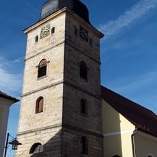
Türgewände, bezeichnet „1793“
Location: Kemnath
Address: Unterer Markt 30
GPS coordinates: 49.86434,11.95135
Latest update: November 21, 2025 11:47
St. Johannes Nepomuk (Waldeck)
86 m
Schloßberg
716 m
Kühberg
632 m
Wohnhaus
35 m
Brunnentrog
162 m
Cultural heritage D-3-6137-0070 in Kemnath
489 m
Kriegerdenkmal für die Gefallenen des Ersten Weltkriegs
478 m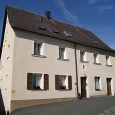
Schlussstein
461 m
Wohnhaus
161 m
Pfarrhaus
64 m
Wohnhaus
74 m
Wohnhaus
68 m
Ehemaliges Schulhaus
132 m
Gasthof
170 m
Wohnhaus
154 m
Scheunenreihe
135 m
Ensemble
68 m
Reste der Zwingermauer
461 m
Tower, Observation tower, scenic viewpoint
715 m
Ostturm
685 m
Wayside cross
315 m
Wayside cross
381 m
Wayside cross
618 m
Wayside cross
704 m
Kriegerdenkmal
478 m
Wayside cross
631 m
Wayside cross
664 m
Wayside cross
400 mReviews
Visited this place? Tap the stars to rate it and share your experience / photos with the community! Try now! You can cancel it anytime.
Discover hidden gems everywhere you go!
From secret cafés to breathtaking viewpoints, skip the crowded tourist spots and find places that match your style. Our app makes it easy with voice search, smart filtering, route optimization, and insider tips from travelers worldwide. Download now for the complete mobile experience.

A unique approach to discovering new places❞
— Le Figaro
All the places worth exploring❞
— France Info
A tailor-made excursion in just a few clicks❞
— 20 Minutes