
Ehem. Gaststätte, satteldachbau, im Inneren an Holzdecke bez. 1798; im Kern älter;
Location: Tännesberg
Address: Tiefe Gasse 10
GPS coordinates: 49.53048,12.32796
Latest update: November 18, 2025 07:28
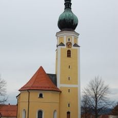
Pfarrkirche St. Michael
249 m
Marktplatz Tännesberg
235 m
Friedhofskapelle
254 m
Cultural heritage D-3-6439-0022 in Tännesberg
253 m
Ehem. Benefiziatenhaus
260 m
Doppelläufiger Mauerzug
174 m
Kirche Marktplatz 1 in Tännesberg
266 m
Gasthaus
278 m
Kreuzwegstation Am Schloßberg 7; Am Schloßberg 19; Am Schloßberg 21; Schloßberg in Tännesberg
343 m
Gasthof
249 m
Gasthof "Zur Sonne"
285 m
Brunnen
227 m
Cultural heritage D-3-6439-0043 in Tännesberg
255 m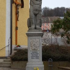
Kriegerdenkmal
242 m
Kelleranlage
147 m
Kreuzwegstation Am Schloßberg 7; Am Schloßberg 19; Am Schloßberg 21; Schloßberg in Tännesberg
343 m
Traufseithaus
217 m
Wohnhaus
239 m
Grabmal Kirchhofgasse 8 in Tännesberg
188 m
Steinplatte
230 m
Grabmal Kirchhofgasse 8 in Tännesberg
200 m
Wohnhaus
279 m
Nebengebäude Marktplatz 4 in Tännesberg
299 m
Hauskeller
241 m
Kreuzwegstation Am Schloßberg 7; Am Schloßberg 19; Am Schloßberg 21; Schloßberg in Tännesberg
342 m
Wohnhaus
290 m
Wayside cross
53 m
Wayside cross
102 mReviews
Visited this place? Tap the stars to rate it and share your experience / photos with the community! Try now! You can cancel it anytime.
Discover hidden gems everywhere you go!
From secret cafés to breathtaking viewpoints, skip the crowded tourist spots and find places that match your style. Our app makes it easy with voice search, smart filtering, route optimization, and insider tips from travelers worldwide. Download now for the complete mobile experience.

A unique approach to discovering new places❞
— Le Figaro
All the places worth exploring❞
— France Info
A tailor-made excursion in just a few clicks❞
— 20 Minutes