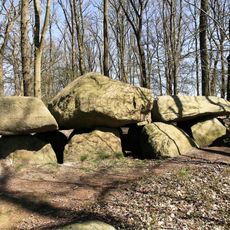
Langelt, nature reserve in Lower Saxony, Germany
Location: Vrees
Inception: November 23, 2018
GPS coordinates: 52.92833,7.78417
Latest update: November 19, 2025 18:53
Teufelssteine Molbergen
3.9 km
Markatal
2.7 km
Großes Tate Meer
4.4 km
St. Prosper
5.5 km
Markatal bei Bischofsbrück
3.8 km
Großsteingräber bei Vrees
2.6 km
Marka zwischen Markhausen und Delschloot
4.7 km
Markatal zwischen Markhausen und Ellerbrock
4.6 km
Ringel-Berg
4 km
Eleonorenhöhe
1.7 km
Langelt
108 m
Varel
6.5 km
Markatal mit Bockholter Dose
187 m
Gehlenborg'sche Scheune
3.4 km
Mahnmal WK I + II
5 km
Gehlenberger Windmühle
5.5 km
Pastors Goarn
5.1 km
Denkmal WK I + II
6.1 km
Ehrenmal WK I + II
3.8 km
Mahnmal WK I + II
4.7 km
Findlinge
4.7 km
Mahnmal WK I + II
5.5 km
Archaeological site
3.9 km
Wayside shrine
5.8 km
Wayside cross
6 km
Memorial stone, memorial
3.5 km
Kolonie Rastdorf 1833 - 1939
4.9 km
Wayside cross
5.2 kmReviews
Visited this place? Tap the stars to rate it and share your experience / photos with the community! Try now! You can cancel it anytime.
Discover hidden gems everywhere you go!
From secret cafés to breathtaking viewpoints, skip the crowded tourist spots and find places that match your style. Our app makes it easy with voice search, smart filtering, route optimization, and insider tips from travelers worldwide. Download now for the complete mobile experience.

A unique approach to discovering new places❞
— Le Figaro
All the places worth exploring❞
— France Info
A tailor-made excursion in just a few clicks❞
— 20 Minutes