LSG-Steckenborn, protected area in Germany
Location: Simmerath
Inception: 2004
GPS coordinates: 50.62938,6.36667
Latest update: November 19, 2025 07:33
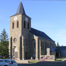
Saint Apollonia Church
975 m
Wolfs- und Wollebachtal
885 m
Gans-Berg
706 m
Altes Schleifrad
152 m
Bunker, ruins
429 m
Scenic viewpoint
1.1 km
Scenic viewpoint
1.1 km
Scenic viewpoint
897 m
Blick auf Woffelsbach/Rursee
832 m
Scenic viewpoint
750 m
Wegekreuz
1.3 km
Wayside cross, Christianity
1.5 km
Wayside cross
635 m
Christianity, wayside shrine
1.4 km
Rurseeblick
920 m
Bunkerrest
732 m
Scenic viewpoint
956 m
Memorial stone, memorial
1.3 km
Wayside shrine
1.5 km
Wayside cross
1.5 km
Wayside cross
1.5 km
Josef Babuschkewitz
1 km
Wayside cross
434 m
Handmühle
783 m
Wayside cross
780 m
Wayside cross
229 m
Weltkriegsgedenkstätte
979 m
Wayside cross
612 mReviews
Visited this place? Tap the stars to rate it and share your experience / photos with the community! Try now! You can cancel it anytime.
Discover hidden gems everywhere you go!
From secret cafés to breathtaking viewpoints, skip the crowded tourist spots and find places that match your style. Our app makes it easy with voice search, smart filtering, route optimization, and insider tips from travelers worldwide. Download now for the complete mobile experience.

A unique approach to discovering new places❞
— Le Figaro
All the places worth exploring❞
— France Info
A tailor-made excursion in just a few clicks❞
— 20 Minutes