LSG-Angelfeld westlich Toennishaeuschen, protected area in Germany
Location: Ahlen
Inception: 1994
GPS coordinates: 51.82576,7.90768
Latest update: November 22, 2025 23:47
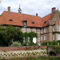
Haus Vorhelm
2.7 km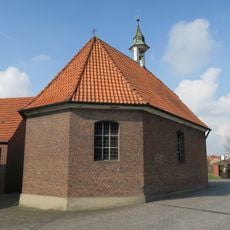
St. Antonius
897 m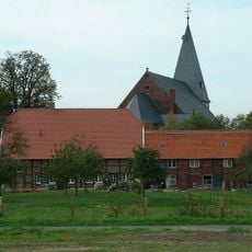
St. Mauritius
3 km
Laubwald im "Bröcker Holz"
2.9 km
Bröckerholz
2.9 km
LSG-Sundern, Haus Vorhelm
2.1 km
Ehrenmal
2.7 km
Wayside cross, Christianity
341 m
Work of art, statue
2.2 km
Work of art, statue, memorial
2.7 km
Kruzifix
2.5 km
Mutter-Gottes-Stein
2.3 km
Wayside shrine
2.9 km
Schräders Kreuz
2.8 km
Baumpfad
469 m
Wayside shrine
2.5 km
Marien Denkmal
2.9 km
Statue, memorial, Work of art
2.6 km
Wayside cross, Christianity
2.9 km
Junker-Voß-Denkmal
3 km
Wayside cross
3 km
Wayside cross
2.6 km
Wayside cross
1.6 km
Augustin-Wibbelt-Spruchstein
1.5 km
Wayside cross
2.8 km
Wayside cross
2.5 km
Wayside shrine, Christianity
2.7 km
Wayside shrine
2.9 kmReviews
Visited this place? Tap the stars to rate it and share your experience / photos with the community! Try now! You can cancel it anytime.
Discover hidden gems everywhere you go!
From secret cafés to breathtaking viewpoints, skip the crowded tourist spots and find places that match your style. Our app makes it easy with voice search, smart filtering, route optimization, and insider tips from travelers worldwide. Download now for the complete mobile experience.

A unique approach to discovering new places❞
— Le Figaro
All the places worth exploring❞
— France Info
A tailor-made excursion in just a few clicks❞
— 20 Minutes