Gebiet bei Bacharach-Steeg, protected area in the European Union defined by the habitats directive in Rheinland-Pfalz, Germany
Location: Perscheid
Location: Breitscheid
Location: Bacharach
Location: Manubach
Inception: 2000
GPS coordinates: 50.04602,7.73067
Latest update: November 21, 2025 22:16
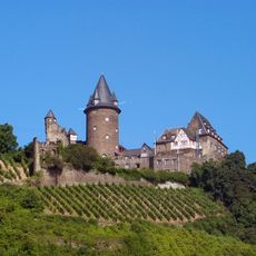
Stahleck Castle
2.8 km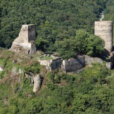
Stahlberg Castle
1.3 km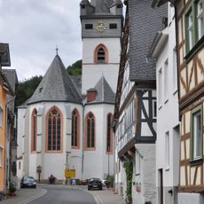
St. Anna (Bacharach-Steeg)
1.4 km
Rabenkopf
1.6 km
Bench, scenic viewpoint
2.2 km
Scenic viewpoint, bench
2.2 km
Römerspuren
2.5 km
Kuhlberturm
2.9 km
Scenic viewpoint, bench
1.2 km
Mönchholzkopf
1.9 km
Bench, scenic viewpoint
2.2 km
Scenic viewpoint
2.9 km
Bench, scenic viewpoint
2.3 km
Bench, scenic viewpoint
2.9 km
Wildgehege
1.6 km
Wildgehege
1.4 km
Scenic viewpoint
2.3 km
Scenic viewpoint
2.8 km
Soonwaldblick
1.6 km
Scenic viewpoint
2.5 km
"Burgenblick"
1.1 km
"Stahlberg-Blick"
1.2 km
Scenic viewpoint
2.5 km
Scenic viewpoint
2.2 km
Scenic viewpoint
1.9 km
Wartturm 14. Jh.
901 m
Wayside cross, Christianity
2.3 km
Ruins
1.4 kmReviews
Visited this place? Tap the stars to rate it and share your experience / photos with the community! Try now! You can cancel it anytime.
Discover hidden gems everywhere you go!
From secret cafés to breathtaking viewpoints, skip the crowded tourist spots and find places that match your style. Our app makes it easy with voice search, smart filtering, route optimization, and insider tips from travelers worldwide. Download now for the complete mobile experience.

A unique approach to discovering new places❞
— Le Figaro
All the places worth exploring❞
— France Info
A tailor-made excursion in just a few clicks❞
— 20 Minutes