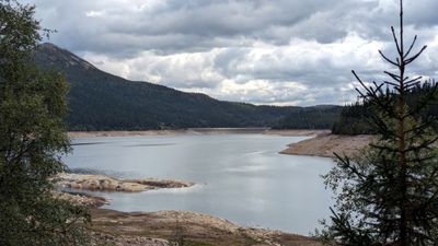
Botnedalsvatn, Artificial lake and reservoir in Tokke, Norway
Botnedalsvatn is a large artificial lake in the valley of Botnedalen, surrounded by forested mountains. A dam controls the water level and supplies water to a hydroelectric power station, while the shoreline is made of rocky, uneven ground.
The lake sits in a valley carved out by glaciers during the last ice age. A dam was built in the 1960s to manage water flow and generate electricity for the region.
The lake's name comes from Botnedalen, the valley where it sits. Today, anglers and hikers visit the area to enjoy the quiet landscape and experience the simple beauty of this still body of water.
The cold water supports trout populations that anglers can catch with proper licenses. Hiking trails run through the surrounding forest and hills, offering views of the mountains and the lake.
The water level rises and falls with the seasons, dropping in dry summer months and exposing parts of the shoreline. In winter, the ice can become thick enough for ice fishing, an unusual winter activity in the area.
The community of curious travelers
AroundUs brings together thousands of curated places, local tips, and hidden gems, enriched daily by 60,000 contributors worldwide.