Ljubljanski vrh, Mountain summit near Vrhnika, Slovenia.
Ljubljanski vrh is a 819 m hill south of Vrhnika whose summit carries a long-range military radar, so the top is closed to the public. No marked trail leads to it, though forest roads and paths from Verd, Borovnica–Pokojišče, Štampetov most–Velika Drnovica and Logatec–Dolgi Tali allow an ascent up to the fenced military perimeter.
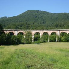
A Roman limes ran below the hill, and its remains are still visible near Štampetov most. In the mid-19th century the Vienna–Trieste railway was built around the northern slope, crossing it on Štampetov most, a smaller version of the Borovniški viaduct. After 1919 the Yugoslav royal army placed bunkers and obstacles on the western approach; in the mid-1970s the JLA built the radar post that closed the summit.
The name links the hill to Ljubljana, though it stands south of Vrhnika. Its wooded slopes are crossed by forest roads and paths, but the fenced military radar station on top keeps visitors out. Below the northern slope, the Štampetov most carried the Vienna–Trieste railway, a smaller version of the Borovniški viadukt.
No marked trail leads to the summit, which is closed to the public inside a fenced military radar area. Forest roads and paths allow the climb to the perimeter: from Verd or Borovnica–Pokojišče by easy road, from Štampetov most via Velika Drnovica or from Logatec via the Dolgi Tali shelter by demanding forest routes.
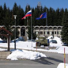
The summit is closed to the public: a long-range military radar has stood on top since the mid-1970s, when the Yugoslav People's Army built the position for its good geographical location. Since 2011 a TRS Ground Master 403 radar with a range of 450 km has operated there.
The community of curious travelers
AroundUs brings together thousands of curated places, local tips, and hidden gems, enriched daily by 95,021 contributors worldwide.