Westbury White Horse, Hill figure in Bratton, England
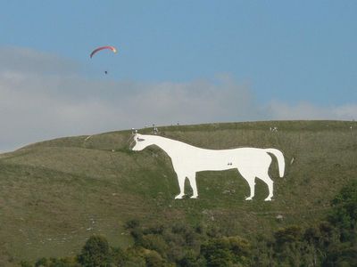
Westbury White Horse is a hill figure in Bratton, England, cut into the escarpment of Salisbury Plain near Westbury in Wiltshire. The chalk-cut shape measures roughly 180 feet (55 meters) tall and 170 feet (52 meters) wide and sits below an Iron Age hillfort.
The current design dates to 1778, when a local steward commissioned a new version on the same slope where an earlier figure stood. That older version from the late 17th century is said to have marked King Alfred's victory over Danish forces in 878.
The white horse faces left with a shape typical of Wessex chalk figures, its clean lines standing out against the green slope. Visitors see the animal best from the foot of the escarpment or from the opposite side of the valley, where the full silhouette comes into view.
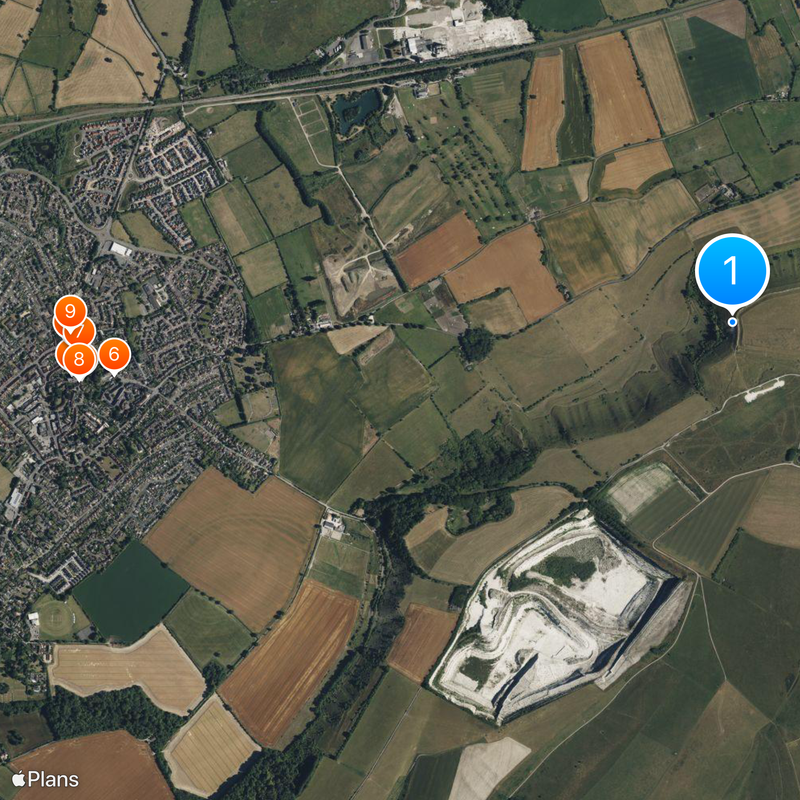
Drive through Newtown and follow Long River Road to reach parking inside the outer earthworks of the hillfort. The path leads over gently rising grassland with firm ground and offers a clear view of the figure after a few minutes.
During World War II, workers covered the entire chalk figure with turf and brushwood to prevent German pilots from using it as a navigation aid. After the war, the community returned and uncovered the figure by removing the covering.
Location: Bratton
Website: https://english-heritage.org.uk/visit/places/bratton-camp-and-white-horse
GPS coordinates: 51.26361,-2.14694
Latest update: December 12, 2025 18:01
Somerset preserves a broad range of historical sites away from the main visitor routes. The region shows medieval abbeys such as Muchelney and Cleeve, Norman castles like Stogursey and Nunney, Elizabethan manor houses including Cothay Manor and Lytes Cary, and prehistoric stone bridges such as Tarr...
Parish Church of All Saints
2.5 km
Old Town Hall, Westbury
2.5 km
Church View
2.4 km
The Ludlow Arms Public House
2.5 km
The Horse And Groom Inn And Adjoining Cottage
2.3 km
Perkin's Pieces
2.4 km
Brookhaven
2.4 km
6-12, Fore Street
2.5 km
25, Market Place
2.4 km
Swansdown House
2.5 km
Stable Building To North Of Vicarage (Courtleigh Nursery School)
2.4 km
The Lodge
2.3 km
War Memorial
2.4 km
24, Market Place
2.4 km
14-18, Fore Street
2.5 km
Albion House
2.5 km
10A, Alfred Street
2.4 km
1-3, Cannon Green
2.5 km
23, Market Place
2.5 km
2 And 4, Fore Street
2.5 km
9, 11, 15 And 15A, Fore Street
2.5 km
Westbury Conservative Club (ferndale House)
2.4 km
Old Alfred House and 10 Alfred Street
2.4 km
Gate Piers To All Saints Churchyard Gate Piers To Churchyard Of Parish Church Of All Saints
2.4 km
7-11, Prospect Square
2.4 km
12-14, Prospect Square
2.4 km
22, Market Place
2.5 km
50, Bratton Road
2.3 kmVisited this place? Tap the stars to rate it and share your experience / photos with the community! Try now! You can cancel it anytime.
Discover hidden gems everywhere you go!
From secret cafés to breathtaking viewpoints, skip the crowded tourist spots and find places that match your style. Our app makes it easy with voice search, smart filtering, route optimization, and insider tips from travelers worldwide. Download now for the complete mobile experience.
A unique approach to discovering new places❞
— Le Figaro
All the places worth exploring❞
— France Info
A tailor-made excursion in just a few clicks❞
— 20 Minutes