Little River County

Log in to your account

AroundUs is a community-driven map of interesting places, built by curious explorers like you. It grows with every review, story, and photo you share.
Connect to save your favorite spots, contribute locations, and create personalized routes.
Continue with Google
Continue with Apple
Continue with X
Continue with Facebook
Continue with email
By continuing, you accept our Terms and Conditions and our Privacy Policy
Create an account
Add to collection
Map
Suggest a change
Share

Little River County, County in southwestern Arkansas, United States.
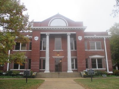
Little River County is an administrative region in southwestern Arkansas that covers a substantial land area with several water bodies throughout. Highway routes including U.S. 59 and U.S. 71 run through the territory, connecting the settlements within its boundaries.

The territory was established on March 5, 1867, created from Sevier County during the Reconstruction period following the Civil War. It takes its name from the Little River that flows through the region.

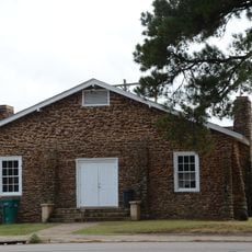
The Two Rivers Museum in Ashdown displays regional artifacts, documents, and photographs that reflect how local communities developed over time. Visitors can explore the daily lives and stories of people who shaped the area through these collected objects and records.

The region is accessible via well-maintained federal highways and state roads that connect its communities. Visitors should plan their route in advance since settlements are spread across the county area, and road conditions are generally best during warmer months.

The territory is separated from other Arkansas counties entirely by water boundaries and shares borders only with Miller County across these waterways. This unusual geographic arrangement makes it one of the few isolated administrative regions in the state.

Location: Arkansas

Inception: March 5, 1867

Capital city: Ashdown

Shares border with: Bowie County, Sevier County, Howard County, Hempstead County, Miller County, McCurtain County

Website: http://littlerivercounty.org

GPS coordinates: 33.69806,-94.22167

Latest update: December 10, 2025 15:57

Photos
Around this place
Beech Street Brick Street
United States of America

Beech Street Brick Street

33.2 km
St. Barnabas Episcopal Church
United States of America

St. Barnabas Episcopal Church

16.5 km
Mineral Springs Waterworks
United States of America

Mineral Springs Waterworks

34 km
Buhrman-Pharr Hardware Company Historic District
United States of America

Buhrman-Pharr Hardware Company Historic District

34.7 km
Beech Street Historic District
United States of America

Beech Street Historic District

33.2 km
Little River County Courthouse
United States of America

Little River County Courthouse

8.7 km
Bottoms House
United States of America

Bottoms House

34.6 km
Judge Jefferson Thomas Cowling House
United States of America

Judge Jefferson Thomas Cowling House

8.9 km
Canaan Baptist Church
United States of America

Canaan Baptist Church

33.9 km
Claude Foulke House
United States of America

Claude Foulke House

34.6 km
Orr School
United States of America

Orr School

34.2 km
Dean House
United States of America

Dean House

33.5 km
John Clifton House
United States of America

John Clifton House

33.5 km
J.K. Wadley House
United States of America

J.K. Wadley House

34.5 km
Little Cossatot River Bridge
United States of America

Little Cossatot River Bridge

30.8 km
Augustus M. Garrison House
United States of America

Augustus M. Garrison House

34.5 km
Alvah Horace Whitmarsh House
United States of America

Alvah Horace Whitmarsh House

34 km
Patrick J. Ahern House
United States of America

Patrick J. Ahern House

34.6 km
First United Methodist Church
United States of America

First United Methodist Church

30.5 km
Hunter-Coulter House
United States of America

Hunter-Coulter House

8.8 km
Hawkins House
United States of America

Hawkins House

16.8 km
Ashdown Commercial Historic District
United States of America

Ashdown Commercial Historic District

8.8 km
Little River County Training School Historic District
United States of America

Little River County Training School Historic District

8.8 km
Kittrell House
United States of America

Kittrell House

34.1 km
Nashville American Legion Building
United States of America

Nashville American Legion Building

43.2 km
S.S.P. Mills and Son Building
United States of America

S.S.P. Mills and Son Building

8.3 km
Lockesburg Waterworks
United States of America

Lockesburg Waterworks

30.5 km
Williams Theater
United States of America

Williams Theater

8.9 km
Show the full map
Reviews

Visited this place? Tap the stars to rate it and share your experience / photos with the community! Try now! You can cancel it anytime.

« Little River County - County in southwestern Arkansas, United States » is provided by Around Us (aroundus.com). Images and texts are derived from Wikimedia project under a Creative Commons license. You are allowed to copy, distribute, and modify copies of this page, under the conditions set by the license, as long as this note is clearly visible.

Discover hidden gems everywhere you go!

From secret cafés to breathtaking viewpoints, skip the crowded tourist spots and find places that match your style. Our app makes it easy with voice search, smart filtering, route optimization, and insider tips from travelers worldwide. Download now for the complete mobile experience.

Around Us App Screenshot

A unique approach to discovering new places

Le Figaro

All the places worth exploring

France Info

A tailor-made excursion in just a few clicks

20 Minutes