Enable Location

We need your location to show you interesting places around you

Discover nearby places

Find interesting locations and hidden gems around you

Precise directions

Get accurate directions and distances to places

Your location is never shared with other users. It's only used when you tap the location button.

Interstate 64

Log in to your account

Start exploring — it's free

Trusted by 63,931 travelers worldwide

Continue with Google
Continue with Apple
or

We will send you a code to connect

By continuing, you accept our Terms and Conditions and our Privacy Policy

Check your inbox

We've sent a pincode in your inbox. Please enter the code below.

Interstate 64
Discussion Reviews 4 Photos
58.3k Popularity

Interstate 64, Interstate highway in Missouri, Kentucky, West Virginia, Virginia

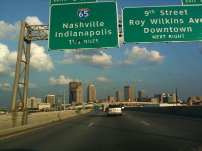
Interstate 64 is a long-distance highway in the mid-eastern United States, running 963 miles (1,550 km) from Wentzville, Missouri to Chesapeake, Virginia. It passes through urban centers such as St. Louis, Louisville, and Richmond, as well as rural regions across Missouri, Kentucky, West Virginia, and Virginia.

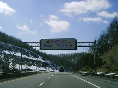
Construction of this highway began in 1957 in Cabell County, West Virginia, with the first segment opening in 1960 between US Route 60 and Ona. The complete connection through all four states was completed gradually over several decades.

The naming after Cecil H. Underwood honors a former West Virginia governor, with signs bearing his name appearing along the route. Additional markers recognize nurses who served in the military, particularly on the segment through Charleston.

Emergency truck escape ramps at Sandstone Mountain help drivers of heavy vehicles on a steep seven percent downgrade that requires extra attention. Motorists should watch for changing road conditions and weather in the mountainous terrain of West Virginia.

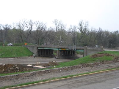
This road crosses the Kanawha River four times and the New River once, requiring extensive engineering work for bridge construction and maintenance. The multiple river crossings over a short distance are uncommon for a highway of this type.

The community of curious travelers

AroundUs brings together thousands of curated places, local tips, and hidden gems, enriched daily by 60,000 contributors worldwide.

Start exploring
Location
Location
Location
Location
Inception
1961
GPS coordinates
38.38207,-89.11694
Latest update
December 13, 2025 19:37
Around this place
Carlyle Lake
United States of America

Carlyle Lake

33.4 km
Rend Lake
United States of America

Rend Lake

33.2 km
General Dean Suspension Bridge
United States of America

General Dean Suspension Bridge

33 km
United States of America

Third principal meridian

10.5 km
Washington County State Recreation Area
United States of America

Washington County State Recreation Area

22.7 km
Franklin County Jail
United States of America

Franklin County Jail

45.6 km
Perry County Jail
United States of America

Perry County Jail

40.9 km
5th District Appellate Court
United States of America

5th District Appellate Court

19.8 km
Heritage House Museum
United States of America

Heritage House Museum

38.4 km
Cedarhurst Center for the Arts
United States of America

Cedarhurst Center for the Arts

18.1 km
William Jennings Bryan Boyhood Home
United States of America

William Jennings Bryan Boyhood Home

31.1 km
Sesser Opera House
United States of America

Sesser Opera House

32.9 km
Badollet House
United States of America

Badollet House

31.1 km
C. H. Judd House
United States of America

C. H. Judd House

36.9 km
Illinois Central Railroad Water Tower and Pump House
United States of America

Illinois Central Railroad Water Tower and Pump House

48 km
Marion County Courthouse
United States of America

Marion County Courthouse

31.2 km
Mulkeytown Christian Church
United States of America

Mulkeytown Christian Church

46 km
Clinton County Courthouse
United States of America

Clinton County Courthouse

33.6 km
Charles and Naomi Bachmann House
United States of America

Charles and Naomi Bachmann House

31.1 km
Centralia Commercial Historic District
United States of America

Centralia Commercial Historic District

16.3 km
Washington County Courthouse
United States of America

Washington County Courthouse

23.6 km
Sentinel Building
United States of America

Sentinel Building

16 km
Franklin County Courthouse
United States of America

Franklin County Courthouse

46.2 km
Perry County Courthouse
United States of America

Perry County Courthouse

40.8 km
West Franklin Historical Museum
United States of America

West Franklin Historical Museum

46.1 km
Centralia Elks Lodge
United States of America

Centralia Elks Lodge

16.2 km
Methodist Episcopal Church
United States of America

Methodist Episcopal Church

31.2 km
Kościół św. Michała Archanioła w Radomiu
United States of America

Kościół św. Michała Archanioła w Radomiu

13.1 km
Show the full map
Reviews
Share your experience

No review yet

Discussions
Start a discussion...

No discussion yet

« Interstate 64 - Interstate highway in Missouri, Kentucky, West Virginia, Virginia » is provided by Around Us (aroundus.com). Images and texts are derived from Wikimedia project under a Creative Commons license. You are allowed to copy, distribute, and modify copies of this page, under the conditions set by the license, as long as this note is clearly visible.

Discover hidden gems everywhere you go!

From secret cafés to breathtaking viewpoints, skip the crowded tourist spots and find places that match your style. Our app makes it easy with voice search, smart filtering, route optimization, and insider tips from travelers worldwide. Download now for the complete mobile experience.

Around Us App Screenshot

A unique approach to discovering new places

Le Figaro

All the places worth exploring

France Info

A tailor-made excursion in just a few clicks

20 Minutes

Around Us
Travel Guide & Maps
Download

Send to your phone

QR Code
1

Open the camera app on your mobile.

2

Point at the QR code with your camera. A notification will appear.

3

Tap the notification to open the link.