Enable Location

We need your location to show you interesting places around you

Discover nearby places

Find interesting locations and hidden gems around you

Precise directions

Get accurate directions and distances to places

Your location is never shared with other users. It's only used when you tap the location button.

Scott County

Log in to your account

Start exploring — it's free

Trusted by 61,688 travelers worldwide

Continue with Google
Continue with Apple
or

We will send you a code to connect

By continuing, you accept our Terms and Conditions and our Privacy Policy

Check your inbox

We've sent a pincode in your inbox. Please enter the code below.

Scott County, Administrative county in Kentucky, United States

Description

Scott County is an administrative county in north-central Kentucky that spreads across farmland and residential areas. The region combines rural and urban spaces, with Georgetown serving as the administrative center.

History

The region was established on June 22, 1792, and named after General Charles Scott, who served during the American Revolutionary War. This timing coincided with Kentucky's early years as a newly formed state.

Culture

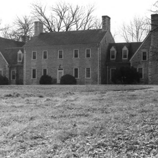
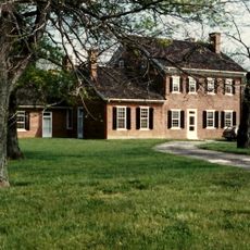
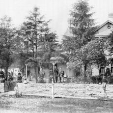
Georgetown, the county seat, displays buildings from the 18th and 19th centuries that reflect how early Kentucky communities were built and developed. Walking through town, you can see the architectural choices people made during those periods.

Practical

The county sits along Interstate 75 and U.S. Highway 460, offering direct connections to major cities like Lexington and Frankfort. These transportation routes make it easy to navigate and explore the region.

Did you know?

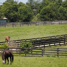
The region has deep roots in farming and livestock production that continue to shape the landscape today. This agricultural foundation has guided how communities here have grown and organized themselves over time.

Location
Inception
June 22, 1792
Capital city
Georgetown
Shares border with
Grant County, Harrison County, Bourbon County, Fayette County, Woodford County, Franklin County, Owen County
GPS coordinates
38.30000,-84.58000
Latest update
December 7, 2025 19:25

AroundUs brings together thousands of curated places, local tips, and hidden gems, enriched daily by 60,000 contributors worldwide. Discover all places nearby (Kentucky).

Around this place
Kentucky Horse Park
United States of America

Kentucky Horse Park

17.4 km
Old Friends Equine
United States of America

Old Friends Equine

13.5 km
United States of America

Mount Horeb Earthworks Complex

18.6 km
Royal Spring Park
United States of America

Royal Spring Park

10.2 km
Yuko-En on the Elkhorn
United States of America

Yuko-En on the Elkhorn

9.1 km
Cardome Centre
United States of America

Cardome Centre

8.7 km
Confederate Monument in Georgetown
United States of America

Confederate Monument in Georgetown

11.4 km
Alexander Plantation House
United States of America

Alexander Plantation House

22.2 km
Switzer Covered Bridge
United States of America

Switzer Covered Bridge

15.9 km
Martyrs Monument in Midway
United States of America

Martyrs Monument in Midway

19.7 km
Midway Historic District
United States of America

Midway Historic District

19.5 km
Payne-Desha House
United States of America

Payne-Desha House

9.8 km
Scott County Courthouse
United States of America

Scott County Courthouse

10.2 km
Hawkins House
United States of America

Hawkins House

10.6 km
Hurricane Hall
United States of America

Hurricane Hall

18.7 km
Branham House
United States of America

Branham House

10.4 km
Cardinal Hill Reservoir Gatehouse
United States of America

Cardinal Hill Reservoir Gatehouse

20.3 km
Holy Trinity Episcopal Church
United States of America

Holy Trinity Episcopal Church

10.4 km
First African Baptist Church and Parsonage
United States of America

First African Baptist Church and Parsonage

9.9 km
Shropshire House
United States of America

Shropshire House

10.2 km
Weisenberger Mills and Related Buildings
United States of America

Weisenberger Mills and Related Buildings

20 km
Millspring
United States of America

Millspring

9.7 km
Georgetown College Historic Buildings
United States of America

Georgetown College Historic Buildings

10.6 km
South Broadway Neighborhood District
United States of America

South Broadway Neighborhood District

11 km
Georgetown East Main Street Residential District
United States of America

Georgetown East Main Street Residential District

10.3 km
Johnston-Jacobs House
United States of America

Johnston-Jacobs House

10 km
Cynthiana Commercial District
United States of America

Cynthiana Commercial District

17.9 km
International Museum of the Horse
United States of America

International Museum of the Horse

17.4 km
Show the full map
« Scott County - Administrative county in Kentucky, United States » is provided by Around Us (aroundus.com). Images and texts are derived from Wikimedia project under a Creative Commons license. You are allowed to copy, distribute, and modify copies of this page, under the conditions set by the license, as long as this note is clearly visible.

Discover hidden gems everywhere you go!

From secret cafés to breathtaking viewpoints, skip the crowded tourist spots and find places that match your style. Our app makes it easy with voice search, smart filtering, route optimization, and insider tips from travelers worldwide. Download now for the complete mobile experience.

Around Us App Screenshot

A unique approach to discovering new places

Le Figaro

All the places worth exploring

France Info

A tailor-made excursion in just a few clicks

20 Minutes

Around Us
Travel Guide & Maps
Download

Send to your phone

QR Code
1

Open the camera app on your mobile.

2

Point at the QR code with your camera. A notification will appear.

3

Tap the notification to open the link.