Enable Location

We need your location to show you interesting places around you

Discover nearby places

Find interesting locations and hidden gems around you

Precise directions

Get accurate directions and distances to places

Your location is never shared with other users. It's only used when you tap the location button.

Log in to your account

Start exploring — it's free

Trusted by 62,447 travelers worldwide

Continue with Google
Continue with Apple
or

We will send you a code to connect

By continuing, you accept our Terms and Conditions and our Privacy Policy

Check your inbox

We've sent a pincode in your inbox. Please enter the code below.

Capital Area Greenbelt

Capital Area Greenbelt

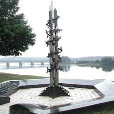
The Capital Area Greenbelt is a roughly 20-mile trail that loops around Harrisburg, passing through parks, wooded areas, and along the Susquehanna River. The path features paved sections, gravel stretches, and natural dirt trails that connect different parts of the city.

The Greenbelt was designed by landscape artist Warren Manning, who worked in the style of Frederick Law Olmsted, with help from community volunteers. Volunteers initially laid grass and wood chips to build it, and many sections were later paved to improve accessibility.

The name reflects its purpose as a green ring around the city where people connect with nature. You will see local residents walking, jogging, and biking here regularly, making it a gathering space where the community spends time outdoors and watches the seasons change throughout the year.

Park at City Island for the most convenient access, reached via Second Street, or start from other entry points like Wildwood Lake Sanctuary to explore different sections. Bring comfortable shoes and water since facilities along the trail are limited, though many parts are accessible for wheelchairs and all ages.

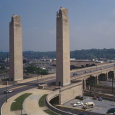
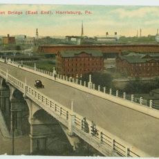
The Walnut Street Bridge, also called the Peoples Bridge, dates to 1889 and was originally built for streetcars, later converted for cars, and now serves only pedestrians and cyclists. The bridge was damaged by Hurricane Agnes in 1972 and partially destroyed by flooding in 1996, but is now being restored with help from a conservation group.

The community of curious travelers

AroundUs brings together thousands of curated places, local tips, and hidden gems, enriched daily by 60,000 contributors worldwide.

Start exploring
GPS coordinates
40.28317,-76.87196
Latest update
February 9, 2026 08:23
Around this place
Pennsylvania State Capitol
United States of America

Pennsylvania State Capitol

2.3 km
Pennsylvania Governor's Residence
United States of America

Pennsylvania Governor's Residence

2.3 km
Pennsylvania State Capitol Complex
United States of America

Pennsylvania State Capitol Complex

2.2 km
United States of America

Commonwealth

2.3 km
State Street Bridge
United States of America

State Street Bridge

1.9 km
Cathedral of Saint Patrick
United States of America

Cathedral of Saint Patrick

2.5 km
Susquehanna Art Museum
United States of America

Susquehanna Art Museum

2 km
Zembo Shrine Building
United States of America

Zembo Shrine Building

2.5 km
Ronald Reagan Federal Building
United States of America

Ronald Reagan Federal Building

2.6 km
Harrisburg Military Post
United States of America

Harrisburg Military Post

541 m
Harris Switch Tower
United States of America

Harris Switch Tower

2.1 km
Kesher Israel Congregation
United States of America

Kesher Israel Congregation

2.3 km
Mulberry Street Bridge
United States of America

Mulberry Street Bridge

2.5 km
Holocaust Memorial for the Commonwealth of Pennsylvania
United States of America

Holocaust Memorial for the Commonwealth of Pennsylvania

2.5 km
Harrisburg Midtown Arts Center
United States of America

Harrisburg Midtown Arts Center

2.2 km
National Civil War Museum
United States of America

National Civil War Museum

1.9 km
Dauphin County Veteran's Memorial Obelisk
United States of America

Dauphin County Veteran's Memorial Obelisk

2.6 km
Old Uptown Historic District
United States of America

Old Uptown Historic District

2.2 km
Old Midtown Historic District
United States of America

Old Midtown Historic District

2.4 km
Harrisburg Technical High School
United States of America

Harrisburg Technical High School

2.3 km
Mount Pleasant Historic District
United States of America

Mount Pleasant Historic District

2.4 km
Sheffield Apartments
United States of America

Sheffield Apartments

2 km
Wesley Union African Methodist Episcopal Zion Church
United States of America

Wesley Union African Methodist Episcopal Zion Church

1.9 km
William Donaldson House
United States of America

William Donaldson House

2 km
William Seel Building
United States of America

William Seel Building

2.5 km
State Museum of Pennsylvania
United States of America

State Museum of Pennsylvania

2.2 km
Old Downtown Harrisburg Commercial Historic District
United States of America

Old Downtown Harrisburg Commercial Historic District

2.6 km
Kunkel Building
United States of America

Kunkel Building

2.6 km
Show the full map
« Capital Area Greenbelt » is provided by Around Us (aroundus.com). Images and texts are derived from Wikimedia project under a Creative Commons license. You are allowed to copy, distribute, and modify copies of this page, under the conditions set by the license, as long as this note is clearly visible.

Discover hidden gems everywhere you go!

From secret cafés to breathtaking viewpoints, skip the crowded tourist spots and find places that match your style. Our app makes it easy with voice search, smart filtering, route optimization, and insider tips from travelers worldwide. Download now for the complete mobile experience.

Around Us App Screenshot

A unique approach to discovering new places

Le Figaro

All the places worth exploring

France Info

A tailor-made excursion in just a few clicks

20 Minutes

Around Us
Travel Guide & Maps
Download

Send to your phone

QR Code
1

Open the camera app on your mobile.

2

Point at the QR code with your camera. A notification will appear.

3

Tap the notification to open the link.