Enable Location

We need your location to show you interesting places around you

Discover nearby places

Find interesting locations and hidden gems around you

Precise directions

Get accurate directions and distances to places

Your location is never shared with other users. It's only used when you tap the location button.

Log in to your account

Start exploring — it's free

Trusted by 61,993 travelers worldwide

Continue with Google
Continue with Apple
or

We will send you a code to connect

By continuing, you accept our Terms and Conditions and our Privacy Policy

Check your inbox

We've sent a pincode in your inbox. Please enter the code below.

Des Moines Rapids

Des Moines Rapids, Rapids on Mississippi River between Nauvoo, Illinois and Keokuk, Iowa, United States

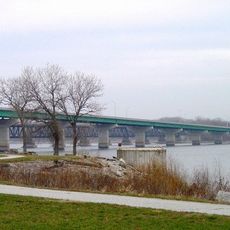
Des Moines Rapids is a section of the Mississippi River between Nauvoo, Illinois and Keokuk, Iowa, where water flows over limestone formations creating turbulent conditions. The rapids span an area with varying depths and numerous rocks beneath the surface that demand careful navigation.

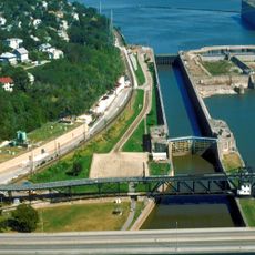
By the late 1830s, the rapids had become a major obstacle to river traffic until engineers blasted a navigation channel through the rocks to improve passage. These efforts marked a turning point in how the middle Mississippi was settled and used by expanding communities.

The rapids served as a meeting point where river travelers and local communities connected and conducted business together. Stories of these exchanges reflect how important the river was as a trade route in earlier times.

This location requires special attention when traveling by water, especially during low-water periods when rocks come closer to the surface. It helps to use local knowledge or experienced guides to navigate safely through this turbulent section.

The rapids were the center of the Honey War in the 1830s, an unusual conflict between Missouri and Iowa over territorial claims. This nearly forgotten border dispute shows how much control of the river mattered to states at that time.

The community of curious travelers

AroundUs brings together thousands of curated places, local tips, and hidden gems, enriched daily by 60,000 contributors worldwide.

Start exploring
GPS coordinates
40.46954,-91.37070
Latest update
December 10, 2025 20:05
Around this place
Nauvoo Illinois Temple
United States of America

Nauvoo Illinois Temple

9.1 km
Lock and Dam No. 19
United States of America

Lock and Dam No. 19

8.2 km
Nauvoo House
United States of America

Nauvoo House

8 km
Joseph Smith Mansion House
United States of America

Joseph Smith Mansion House

8.1 km
Nauvoo Historic District
United States of America

Nauvoo Historic District

8.8 km
Keokuk Rail Bridge
United States of America

Keokuk Rail Bridge

8.7 km
Keokuk–Hamilton Bridge
United States of America

Keokuk–Hamilton Bridge

8.8 km
George M. Verity
United States of America

George M. Verity

8.8 km
C. R. Joy House
United States of America

C. R. Joy House

7.3 km
Keokuk National Cemetery
United States of America

Keokuk National Cemetery

8.3 km
Gen. William Worth Belknap House
United States of America

Gen. William Worth Belknap House

8.1 km
Gen. Samuel R. Curtis House
United States of America

Gen. Samuel R. Curtis House

8.3 km
E. H. Harrison House
United States of America

E. H. Harrison House

8.2 km
St. Barnabas Episcopal Church
United States of America

St. Barnabas Episcopal Church

8 km
St. John's Episcopal Church
United States of America

St. John's Episcopal Church

8.2 km
United States Post Office and Courthouse
United States of America

United States Post Office and Courthouse

8.1 km
Frank J. Weess House
United States of America

Frank J. Weess House

8.2 km
John N. and Mary L. Irwin House
United States of America

John N. and Mary L. Irwin House

7.6 km
Alois and Annie Weber House
United States of America

Alois and Annie Weber House

7.5 km
Hugh W. and Sarah Sample House
United States of America

Hugh W. and Sarah Sample House

8.4 km
The Park Place-Grand Avenue Residential District
United States of America

The Park Place-Grand Avenue Residential District

7.2 km
Keokuk Young Women's Christian Association Building
United States of America

Keokuk Young Women's Christian Association Building

8.2 km
William J. Reimbold House
United States of America

William J. Reimbold House

8.8 km
Cyrus Felt House
United States of America

Cyrus Felt House

4 km
Family Living Center
United States of America

Family Living Center

8.9 km
Hunziker Winery Site
United States of America

Hunziker Winery Site

12.4 km
Arrowhead Bowl
United States of America

Arrowhead Bowl

6.1 km
Red Brick Store
United States of America

Red Brick Store

8.1 km
Show the full map
« Des Moines Rapids - Rapids on Mississippi River between Nauvoo, Illinois and Keokuk, Iowa, United States » is provided by Around Us (aroundus.com). Images and texts are derived from Wikimedia project under a Creative Commons license. You are allowed to copy, distribute, and modify copies of this page, under the conditions set by the license, as long as this note is clearly visible.

Discover hidden gems everywhere you go!

From secret cafés to breathtaking viewpoints, skip the crowded tourist spots and find places that match your style. Our app makes it easy with voice search, smart filtering, route optimization, and insider tips from travelers worldwide. Download now for the complete mobile experience.

Around Us App Screenshot

A unique approach to discovering new places

Le Figaro

All the places worth exploring

France Info

A tailor-made excursion in just a few clicks

20 Minutes

Around Us
Travel Guide & Maps
Download

Send to your phone

QR Code
1

Open the camera app on your mobile.

2

Point at the QR code with your camera. A notification will appear.

3

Tap the notification to open the link.