Rettelkirchspitze, Mountain summit in Wölzer Tauern, Austria.
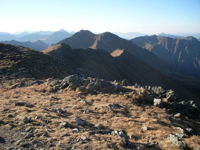
Rettelkirchspitze is a mountain summit in the Wölzer Tauern region that stands at 2,475 meters with distinctive red-toned rock formations throughout its structure. Marble deposits lie near its southern face and contribute to the geological character of the area.
The area around this summit was the site of mining operations during the 19th century, when miners discovered significant amphibolite deposits in the region. These extraction activities left traces in the local geology and landscape use.
The mountain's name comes from the red-tinted rocks that define its appearance and its prominence as a standalone peak. Visitors notice these distinctive rock colors while climbing through the different sections of the route.
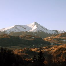
The ascent starts from Neunkirchner Hütte at roughly 1,535 meters (5,035 feet) and follows the eastern ridge trail to reach the summit. The route takes about three hours and includes steep sections with some exposed passages that require care.
This peak forms part of a ridge that branches southeast from the main Alpine divide at Hochstubofen and separates two different valleys below. This geographic position makes it a natural landmark for understanding the region's watershed.
GPS coordinates: 47.25995,14.12728
Latest update: December 14, 2025 09:46
Greim
2.3 km
Günstner Wasserfall
9.3 km
Pfarrkirche hl. Nikolaus, Sankt Nikolai im Sölktal
9 km
Baierdorf St. Nikolaus, Filialkirche
7.8 km
Parish church of Sankt Peter am Kammersberg
9.2 km
Mariä Geburt
8.7 km
Karner Sankt Peter am Kammersberg
9.3 km
Heimatmuseum Sankt Nikolai im Sölktal
9 km
Friedhof mit Initienkapellen
8.9 km
Hofkapelle Bauernhaus Hofmoar, Schöder
8.8 km
Josefikapelle, Feistritz am Kammersberg
7.7 km
Kalvarienbergkapelle Schöder
8.5 km
Wegkapelle hl. Johannes Nepomuk (Pestkapelle)
8.8 km
Bauernhof Bergler, Sankt Nikolai im Sölktal
9 km
Bauernhaus Hofmoar, Schöder
8.7 km
Schloss Feistritz, St. Peter am Kammersberg
8.3 km
Gotischer Bildstock, Färberkreuz
8.8 km
Karner hl. Anna
8.7 km
Kriegerdenkmal
9 km
Webermichlkreuz
9.6 km
Wehranlage Baierdorf
7.8 km
Schalensteine StPeter/Kmbg
4.3 km
Kötzlmühle, Feistritz am Kammersberg
7.7 km
Kötzlmühle, Feistritz am Kammersberg - barn
7.7 km
Wohnhaus, ehem. Pfarrhof mit Pfeilerstadl
9.4 km
Pfarrhof mit Wirtschaftsgebäude
8.7 km
Duscherhaus Schöder
8.7 km
Ehem. Mesnerhaus
8.7 kmVisited this place? Tap the stars to rate it and share your experience / photos with the community! Try now! You can cancel it anytime.
Discover hidden gems everywhere you go!
From secret cafés to breathtaking viewpoints, skip the crowded tourist spots and find places that match your style. Our app makes it easy with voice search, smart filtering, route optimization, and insider tips from travelers worldwide. Download now for the complete mobile experience.
A unique approach to discovering new places❞
— Le Figaro
All the places worth exploring❞
— France Info
A tailor-made excursion in just a few clicks❞
— 20 Minutes