Lichtervelde railway station, railway station in Belgium
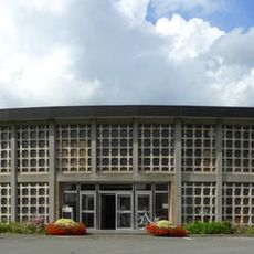
Lichtervelde railway station is a decommissioned station building in Belgium made of grey brick with design features typical of the late 1800s. The structure features large windows, a peaked roof, and originally contained waiting rooms, ticket offices, and the station master's residence within its elongated form.
The station opened in 1847 as part of Belgium's rapid railway network expansion across the country. The building suffered damage during World War I and was subsequently rebuilt to match its original design, preserving its historic character.
The station building displays tile panels showing the local horse market that once thrived in the town. These decorative elements reflect how the railway station was woven into the community's commercial life and served as a hub for traders and farmers.
The station is easily reached on foot or by bike from the town center and offers visitors the chance to view the historic building and old track layout. The site is open and accessible for sightseeing, making it a good spot for a leisurely walk while imagining what daily train operations were like.
A small wooden building next to the main station, called a lampistry, was once used to fill and maintain oil lamps that lit the station and tracks. This modest structure reveals the level of care taken in keeping these historical railway facilities safe and functioning.
The community of curious travelers
AroundUs brings together thousands of curated places, local tips, and hidden gems, enriched daily by 60,000 contributors worldwide.