Chest opened
+${chestReward.xp} XP
Explorer
NOUVEAU ×${chestReward.collectible.quantity}
tapez pour fermer

See the monuments around you in AR Open chests in the app

Around Us is built for your phone — point your camera at the streets and discover the monuments and places around you in augmented reality. Around Us is built for your phone — chests unlock when you walk, explore and capture nearby places.

•

Enable Location

We need your location to show you interesting places around you

Discover nearby places

Find interesting locations and hidden gems around you

Precise directions

Get accurate directions and distances to places

Your location is never shared with other users. It's only used when you tap the location button.

Murumendi

Log in to your account

Start exploring — it's free

Trusted by 93,987 travelers worldwide

Continue with Google
Continue with Apple
or

We will send you a code to connect

By continuing, you accept our Terms and Conditions and our Privacy Policy

Check your inbox

We've sent a pincode in your inbox. Please enter the code below.

Murumendi

Murumendi, Mountain summit in Basque Country, Spain

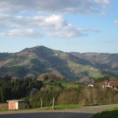
Murumendi is a mountain summit in the Basque Country reaching about 868 meters in elevation. Several hiking routes cross its slopes, passing through forest sections and grassland areas with varying levels of difficulty.

Murumendi's summit holds traces of an Iron Age hillfort. In 1976 a small steel cross was placed on a concrete base in memory of Sebastian Sanchez, Fernando Terradillos and Jose Luis Orbegozo, who died on Viñamala that year. A stele commemorates ethnologist Luis Pedro Peña Santiago, who died in 1994.

In Basque mythology Murumendi is one of the homes of Mari, the main goddess, who crosses the sky as a fireball from the Muru cave to her dwelling near Txindoki. Legend also places the Dama de Murumendi in the Damazulo cave on the north-west slope. Since 1990 Beasain opens its Loinatz festivities with Mari's Descent, when she flies down to San Martín square.

Sturdy hiking boots and plenty of water are necessary for the climb, especially when the weather can shift rapidly. Weather-resistant clothing helps protect against quick changes in conditions at higher elevations.

The summit holds the remains of an Iron Age hillfort, and megalithic traces are visible across the range: seven in total, with at least one more lost. The orientation table, inaugurated on 22 June 1997, is based on a hand-drawn colour picture by Estanislao Iturriotz Barandiaran and lists around a hundred peaks with their heights and distances.

The community of curious travelers

AroundUs brings together thousands of curated places, local tips, and hidden gems, enriched daily by 93,987 contributors worldwide.

Start exploring
GPS coordinates
43.09138,-2.20256
Latest update
October 31, 2026 13:31
Reviews
Share your experience

No review yet

Discussions
Start a discussion...

No discussion yet

« Murumendi - Mountain summit in Basque Country, Spain » is provided by Around Us (aroundus.com). Images and texts are derived from Wikimedia project under a Creative Commons license. You are allowed to copy, distribute, and modify copies of this page, under the conditions set by the license, as long as this note is clearly visible.

Discover hidden gems everywhere you go!

From secret cafés to breathtaking viewpoints, skip the crowded tourist spots and find places that match your style. Our app makes it easy with voice search, smart filtering, route optimization, and insider tips from travelers worldwide. Download now for the complete mobile experience.

Around Us App Screenshot
❝

A unique approach to discovering new places❞

— Le Figaro

❝

All the places worth exploring❞

— France Info

❝

A tailor-made excursion in just a few clicks❞

— 20 Minutes

Around Us
Travel Guide & Maps
Download

Send to your phone

QR Code
1

Open the camera app on your mobile.

2

Point at the QR code with your camera. A notification will appear.

3

Tap the notification to open the link.