Chest opened
+${chestReward.xp} XP
Explorer
NOUVEAU ×${chestReward.collectible.quantity}
tapez pour fermer

See the monuments around you in AR Open chests in the app

Around Us is built for your phone — point your camera at the streets and discover the monuments and places around you in augmented reality. Around Us is built for your phone — chests unlock when you walk, explore and capture nearby places.

•

Enable Location

We need your location to show you interesting places around you

Discover nearby places

Find interesting locations and hidden gems around you

Precise directions

Get accurate directions and distances to places

Your location is never shared with other users. It's only used when you tap the location button.

Sierra Blanquilla

Log in to your account

Start exploring — it's free

Trusted by 94,752 travelers worldwide

Continue with Google
Continue with Apple
or

We will send you a code to connect

By continuing, you accept our Terms and Conditions and our Privacy Policy

Check your inbox

We've sent a pincode in your inbox. Please enter the code below.

Sierra Blanquilla

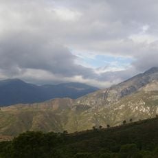
Sierra Blanquilla, Mountain summit in Andalusia, Spain

Sierra Blanquilla is a limestone mountain between El Burgo and Ronda, north of the Sierra de las Nieves natural park. Its highest point, the Pico del Viento, reaches 1,428 m. The slopes are dolomite and limestone with flint, cut by karst platforms, and carry holm oak, Aleppo pine and kermes oak scrub.

Sierra Blanquilla belongs to the Subbetic unit of the Betic Cordillera, built up mainly from dolomites, limestones and limestones with flint, with marls and clays. Its highest point is the Viento peak at 1,428 m. The range was declared a Special Area of Conservation in 2006 and lies within the Sierra de las Nieves Biosphere Reserve.

Local shepherds have used the slopes for grazing across generations, maintaining the natural grasslands through their traditional practices. This way of life continues to shape how the land looks and feels today.

Several hiking trails connect this peak with the nearby town of Ronda, and the main route to the summit takes several hours of walking. Start early in the day and bring plenty of water, as the exposed slopes offer little shade.

The summit is the Pico del Viento, 1,428 m high, according to Spanish sources; the Swedish entry gives 1,304 m. The sierra lies just north of the Sierra de las Nieves natural park and, though outside it, belongs to the Sierra de las Nieves biosphere reserve and its associated ZEPA bird protection area. It was also designated a Zona de Especial Conservación in 2006.

The community of curious travelers

AroundUs brings together thousands of curated places, local tips, and hidden gems, enriched daily by 94,752 contributors worldwide.

Start exploring
GPS coordinates
36.77606,-5.03679
Latest update
October 31, 2026 22:25
Reviews
Share your experience

No review yet

Discussions
Start a discussion...

No discussion yet

« Sierra Blanquilla - Mountain summit in Andalusia, Spain » is provided by Around Us (aroundus.com). Images and texts are derived from Wikimedia project under a Creative Commons license. You are allowed to copy, distribute, and modify copies of this page, under the conditions set by the license, as long as this note is clearly visible.

Discover hidden gems everywhere you go!

From secret cafés to breathtaking viewpoints, skip the crowded tourist spots and find places that match your style. Our app makes it easy with voice search, smart filtering, route optimization, and insider tips from travelers worldwide. Download now for the complete mobile experience.
Around Us App Screenshot
❝

A unique approach to discovering new places❞

— Le Figaro

❝

All the places worth exploring❞

— France Info

❝

A tailor-made excursion in just a few clicks❞

— 20 Minutes

Around Us
Travel Guide & Maps
Download

Send to your phone

QR Code
1

Open the camera app on your mobile.

2

Point at the QR code with your camera. A notification will appear.

3

Tap the notification to open the link.